Draft Local Plan Review
6. Sustainable Economic Growth
Introduction
110. Solihull has one of the most productive economies in the Midlands. The presence of its key economic assets combined with Solihull's central location on the national motorway and rail networks and the quality of its environment, have been key to its success in attracting investment, particularly in high value-added sectors that include automotive manufacturing, ICT, business and professional services, creative industries and construction. The attractiveness of the Borough to businesses and investors is set to take a significant leap forward with the arrival of the high speed rail link and the Interchange station that is to be accommodated in the Borough.
UK Central
111. The UK Central proposals present a unique opportunity on a nationally significant scale to bring forward major growth. This will contribute to wider strategic ambitions and in doing so make a substantial contribution to the economic growth aims of not just the Council, but also both the WMCA and the GBSLEP. The UK Central area, including The Hub, where key economic assets are located, also encompasses the proposed High Speed 2 Interchange railway station within the triangle of land bounded by the A45, A452 and the M42, now known as Arden Cross.
112. The UKC Masterplan (June 2013) highlights the opportunity as follows:
"At the heart of the proposition is the notion that, by capitalising on one of the strongest economic bases in the country today, the area has the potential to underpin a national economic resurgence. By targeting investment in local infrastructure and committing to deliver an expanded Airport and proposed HS2 station, the benefits for the area and the UK are not only startlingly significant but also very exciting at a time when the country is moving out of one of the worst economic cycles in modern history."
113. The GBSLEP's HS2 Growth Strategy (July 2015) also outlined how to fully maximise the benefits of one of the largest infrastructure projects in Europe – including the need to take advantage of the opportunity for development around the interchange station to create a:
"high value, mixed activity economic growth hub in a highly accessible, well serviced and concentrated urban environment. Through taking an innovative and modern approach to 'garden city' principles that are fit for the current and future era, the development of 'lifestyle districts' in and around the Interchange Station will embrace a range of mixed uses; sustainability techniques; the very best infrastructure; and accessibility."
114. Now that the area's potential has been recognised, it is important that every opportunity is taken to ensure that the vision is realised and delivery gets underway. To help achieve this, an appropriate planning framework is needed that can encourage, guide and facilitate development to take place in a managed and coordinated manner. The approach of this Local Plan Review recognises that delivery of the area's potential will take place over many years and it must remain flexible to ensure that no future opportunities are lost.
115. Delivery isn't just about having an appropriate planning framework in place, and it's in this context that in 2016 the Council established the UK Central Urban Growth Company (UGC) to lead the delivery of the project. In particular its aims are:
- To focus on securing the necessary infrastructure, connectivity and infrastructure improvements to create the optimum environment for investment, new jobs and homes.
- To co-ordinate planning, sequencing and delivery of the infrastructure and wider public transport connectivity across the UK Central Hub Area.
- To work collaboratively with the land owners to inform the masterplan process to optimise financial, social and economic value.
- To work commercially and to realise the development opportunity of the Arden Cross site and the wider benefits this will bring to the Hub.
116. The UGC is bringing together the key stakeholders from The Hub area to develop a concept framework that will illustrate the key components and growth aspirations of the partners; together with an indication of the infrastructure needed to support delivery of the project. The UGC will have an opportunity, through responding to this plan, an opportunity to feed this work into the Local Plan Review process as more detail emerges, and is another reason why a degree of flexibility is required, especially at this stage.
117. It is clear from what has already been described that the Hub area embraces a unique concentration of economic assets and potential which holds out the prospect of making a significant contribution to the Government's aims for job creation and growth. What is needed as part of this plan is a policy approach that allows these assets to flourish whilst providing a framework to ensure that the resulting developments provide a well integrated sense of place, with easy access through the area, and is supported by appropriate infrastructure. The focus of the policy is to ensure these existing, new and expanded assets work together as part of a whole. This will ensure that the 'whole is greater than the sum of the parts'.
|
Policy P1 UK Central Hub Area |
|
The UKC Hub Growth Area (as indicated on the spatial strategy) embraces Birmingham Airport, the NEC, Arden Cross, Birmingham Business Park and JLR (which are each key economic assets) and seeks to support their future aspirations in a holistic, well connected way, together with the development of the HS2 Interchange Station. Development proposals within the growth area will be expected to demonstrate how they achieve the following key objectives : •Contribute towards growth and place making aspirations of the area, •Ensure that connectivity within and beyond the site creates an integrated approach to movement throughout the Hub area, •Make an appropriate contribution towards infrastructure provision •Do not impede the provision of infrastructure necessary to support development elsewhere in the hub area, or otherwise prevent or hinder development occurring in other parts of the Hub area. •Encourages the use of modes of travel other than the private car, •Incorporate high quality design aspirations for both the development and public realm. •Contribute towards the strategic green infrastructure network across the Hub area, •Encompasses sustainability principles, including support for growth and innovation, the development of strong, vibrant and healthy communities, minimising the use of natural resources and incorporating low carbon and renewable energy principles. In addition to the above, the Council will also take into account the following: Arden Cross The Council will support and encourage the development of the Arden Cross land as an exemplary international station, with new public realm that supports the creation of a sense of place supporting the potential for commercial and residential opportunities, that will be well integrated into the surrounding environment, seamlessly linking to Birmingham Airport and the NEC in a well co-ordinated way. The Council will support proposals that include passenger facilities, offices, and residential (together with associated ancillary uses (including retail developments of an appropriate scale)). Land bounded by the M42, A452 and A45 will be removed from the Green Belt to facilitate the use of the site in its contribution towards the aims of the UKC Hub Growth Area. This area of land is shown in the appendices to this plan as site 19. National Exhibition Centre (NEC) To enable the NEC to meet its future aspirations and to drive economic and employment growth, the Council will enable a broad range of developments to enhance visitor offer, diversify facilities and increase international competitiveness. Development the Council will support and encourage will include that needed for operational purposes such as new or refurbished exhibition halls, transport facilities and other development needed to enable the NEC to enhance its international competitiveness. The Council will also support a broad range of ancillary and complementary facilities needed to enhance visitor experience and support operational needs. These will include hotels, administrative offices, warehouses, catering, meeting space, appropriate leisure and other supporting development, provided it is justified in terms of scale, its support for the NEC as a whole and is appropriately located within the NEC. The Council will also support proposals that contribute towards wider place making objectives including residential development and other business uses. This will particularly be the case in circumstances where it can be demonstrated that surface level car parking is surplus to requirements, or where appropriate compensatory provisions can be made elsewhere (including the use of decked parking). Birmingham Airport The Council will support and encourage further development needed for operational purposes such as passenger and freight facilities, terminals, transport facilities and other development that supports operational needs, or which allows the capacity of the extended runway to be maximised. The Council will also support a broad range of ancillary and complementary facilities including hotels, administrative offices car parks and other appropriate facilities needed to serve the needs of air travellers using the Airport. Proposals should be justified in terms of scale and in terms of supporting the Airport function and be appropriately located so as not to detract from Airport function. Jaguar Land Rover (JLR) The Council will support JLR to compete and further its success in the global vehicles industry. To achieve this JLR site will need to continue to evolve and where necessary expand, the only realistic opportunity for significant expansion is to the north east. The Council will support and encourage the development of JLR within its boundary defined in this Local Plan. This will include a broad range of development needed to maintain or enhance the function of Jaguar Land Rover as a major manufacturer of vehicles. In order to make specific provision for JLR needs during the plan period the Council proposes to release land from the Green Belt to the north east as indicated in the appendix. The land will be protected (at least in part) for JLR operational needs or to enable JLR component suppliers, needed to directly support JLR operational needs, to be located close to the plant. It will be expected that proposals for development of the area will be promoted in a comprehensive and coordinated manner that can make provision for a phased approach, if required. Birmingham Business Park The Council will support and encourage the development of Birmingham Business Park within its boundary defined in this Local Plan to support its role as a prime employment location and enhance its important role as a high quality, managed business park. Development will be supported that includes uses falling in the Business Use Classes (B1, B2 and B8). The Council will expect development to progress in a well planned way that will maintain the attractiveness of the business park to investors and that will protect and enhance the environment including the natural environment. The Council will also support a broad range of ancillary or complementary uses needed to enhance the attraction of the business park to occupiers. These could include hotels, health and fitness, leisure, childcare facilities and local facilities falling within use classes A1 to A5 of a scale that does not compete with existing or planned facilities outside of Birmingham Business Park. |
Justification
118. The policy reflects the Government's commitment, as set out in the NPPF, to securing sustainable economic growth in order to create jobs and prosperity, building on the area's strengths and meeting the challenges of global competition and a low carbon future.
UKC Hub Growth Area
119. The establishment of the UGC is a key factor assisting in the delivery of the development potential of the area. The development of a concept framework plan, by the UGC, for the area will assist in ensuring a comprehensive and coordinated approach is followed. The concept framework will be a non-statutory plan which will be updated from time to time in response to changing circumstances. The need for flexibility is important given the time period development is expected to come forward in the area – i.e. from 2016 to beyond the plan period.
120. A Concept Framework produced on a collaborative basis and supported by all stakeholders will show at a high level how the key objectives set out in Policy P1 will be met. The concept framework will then be expected to be used by those promoting development via planning applications to demonstrate, in greater detail, how the criteria in Policy P1 have been met.
121. It is recognised that given the time span for development to be undertaken, and the uncertainties about what may take place in the later years, there needs to be an increased emphasis on monitoring what does come forward, and what the implications are for the plan. Therefore a bespoke regime will be put in place and this will be overseen by appropriate governance arrangements that the Council will put in place.
122. For purposes relating to housing land supply (which is dealt with in chapter 7), it has been assumed that across the whole UKC Hub Growth Area there will be 1,000 dwellings coming forward in the plan period.
Arden Cross
123. The Arden Cross proposals focus on the HS2 interchange station and the triangle of land east of the NEC bounded by the A45, A452 and M42 (some 140ha in area) and present an important and unique opportunity to maximise economic and social benefits. The prospectus for a Garden City Approach (July 2014) envisages a well planned and vibrant new place. Development is to be guided by strong urban design principles and provision for strong connectivity. It will be a place of combined national and international assets with investment potential and full integration into the environment and economic landscape
124. It will be a place of design excellence offering investment and businesses the potential to benefit from proximity to international significant leaders in high tech industries, space for large-scale campus style opportunities for companies and a digitally connected business environment where a diverse range of large and small businesses can network.
125. The Arden Cross proposals require land to be taken from the Green Belt. The proposals are vitally important to the aim of maximising the economic growth and job creation potential of the Hub area that is of national significance. These will meet the aim of the NPPF to proactively promote economic growth; and through improved connectivity with North Solihull will hold out the prospect of improved access to employment from an area of persistently high unemployment. Arden Cross is a vitally important part of the Hub proposals that seek to meet the needs of key economic assets. It is also important to maximise the efficient use of the Arden Cross land that would not have been possible if the land were not removed from the Green Belt and a simple parkway station developed instead[14]. The Arden Cross Proposals are site specific in that they rely on the development of HS2 and its interchange station that will be built in the Green Belt and will address the needs of key economic assets that are of crucial significance to the local and regional economy. The land will be bounded by main roads that provide strong defensible Green Belt boundaries. There are therefore exceptional circumstances for releasing the Arden Cross land defined in this plan from the Green Belt.
Birmingham Airport
126. The Airport Master Plan (2007)[15] forecasts that passenger related air transport movement will grow substantially over the plan period (2016 throughput 11.6m passengers/year, 2030 throughput 27.2m passengers /year). Forecasts for airport activity and its continuing development indicate a strong market for new investment as evidenced by the extension to the main runway that was completed in 2014.
127. In order to enable the Airport to meet its aspirations a variety of operational development will be required and ancillary and complementary developments to serve the needs of travelling passengers. Appropriate types of development are described in Policy P1.
128. "The Future of Air Transport" White Paper (2003) suggested a second runway may be needed to serve the Airport. Whilst the White paper suggested that the new runway could be needed as early as 2016, it left it for the Airport operator to determine when the project would be commercially viable. Subsequent work by the Airport into passenger forecasts and existing runway capacity indicated that a second runway would not be needed until after 2030 and this position is reflected in the current Airport Master Plan.
129. In October 2016 the Government indicated that it would publish a draft Airports National Planning Statement (NPS) early in 2017. The local plan review will need to respond to this if, and when, necessary. In the meantime the Council believes it is right that the airport should be supported to maximise the capacity and capability of the existing extended runway.
National Exhibition Centre
130. The role of the National Exhibition Centre has evolved since opening in 1976. The NEC is now acknowledged as a venue for major exhibitions, events, tourism and leisure and an important driver of the visitor economy. In order for the NEC to remain competitive in a market where key competitors are international it will need to respond to changing markets and expectation and provide an improved offer. The NEC aspires to maintain its competitive position in the market for hosting major events but also intends to widen its product offer to encompass a wide range of major leisure and entertainment uses. The NEC aims to fulfil its ambitions by:
- Maximising commercial opportunities of current footfall through enhanced activities to increase dwell time at the NEC site;
- Creating new footfall by introducing new facilities as an attractor to the NEC;
- Providing a more compelling sense of arrival to the Region;
- Increasing reputation and brand of the NEC and the Region through partnerships;
- Providing a site that has appeal across ages, cultures and social types.
131. This will require new investment to refurbish or replace halls, create new floorspace and meet new challenges in meeting visitor expectations and on site experiences including improved visitor management, upgraded choice in its food offer and greater opportunities for relaxation and entertainment.
132. There is therefore a need for flexibility to enable a broad range of development that will support operational needs but also a need for ancillary and complementary supporting facilities together with provision for sustainable transport and links to employment opportunities.
133. Developments at the NEC will play a key part in the place-making role that is expected across the Hub area, especially given its position between the Airport and Arden Cross.
Jaguar Land Rover (JLR)
134. The Council will continue to support the further development and modernisation of the vehicles plant in order to enable its continued success in the competitive global vehicles market. Land Rover is constrained in terms of its ability to expand by its location within the main urban area. To reflect this and having regard to the vital importance of Jaguar Land Rover to the region's economy and to job creation, Policy P1 includes proposals to remove land from the Green Belt to support this aim.
135. The land indicated to be removed from the Green Belt also includes land on the south eastern side of Damson Parkway/Old Damson Lane. Given its location it may be attractive to businesses and investments which support the automotive and motorsport industries.
136. The exceptional circumstances to justify this approach are as follows:
- Jaguar Land Rover is a major international business and one of the largest employers in the West Midlands, whose continued growth and success are of vital importance to the local and regional economy, and to the aspirations in the UK Central Masterplan. Failure to provide for future growth and expansion would put the Company at a competitive disadvantage with its motor manufacturing rivals and jeopardise the significant potential for new employment;
- The Lode Lane plant is severely constrained by surrounding residential areas, Elmdon Park and local nature reserves, and the only realistic option for expansion and redevelopment is to the east on Green Belt land;
- There is no suitable alternative that meets the Company's need for contiguous growth to consolidate a single comprehensive site;
- The need for sites in close proximity to the Lode Lane plant to provide opportunities for key supply chain businesses to locate so as to minimise the potential impact of transport delays;
- A significant part of the site already has planning permission for use as a despatch facility which was justified with very special circumstances;
- The land performs only moderately in the Solihull Strategic Green Belt Assessment 2016;
- The creation of a logical and defensible boundary to the Green Belt beyond Damson Parkway/Old Damson Lane that acknowledges the development that has taken place in the area and the area of land taken out of the Green Belt to accommodate the gypsy and traveller site[16].
137. It will be expected that a concept masterplan will be developed for this allocation in a similar manner as to the concept masterplans being sought in relation to the housing allocations detailed in a later chapter.
Birmingham Business Park
138. Most of the remaining area of the business park is committed to development through detailed planning consents. To supplement the land offer of the business park and potentially accelerate the delivery of new employment opportunities and enable stronger links to North Solihull, especially by public transport, a 9.0 hectare site at the south west corner of the business park was allocated in the SLP. This would facilitate a development with a buffer zone of green space between the business park and the residential development along Coleshill Road and Blackfirs Lane. This buffer, together with that existing to the north west of the business park, is to be positively managed and enhanced. This would facilitate public transport access to the site from North Solihull via a new bus link into the business park from Blackfirs Lane that would also link to the National Exhibition Centre.
Challenges and Objectives Addressed by the Policy
A Reducing inequalities in the Borough
B Meeting housing needs across the Borough, including the Borough's own needs and, where possible, assisting with accommodating the HMA wide shortfall.
C Sustaining the attractiveness of the Borough for people who live, work and invest in Solihull
D Securing sustainable economic growth
F Climate change
HIncreasing accessibility and encouraging sustainable travel
J Improving health and well being
K Protecting and enhancing our natural assets
L Water quality and flood risk
M Maximising the economic and social benefits of the High Speed 2 rail link and Interchange
N Mitigating the impacts of High Speed 2 and the growth associated with the Interchange area
(73) 4. Do you agree with Policy P1? If not why not, and what alternative would you suggest?
(45) 5. Do you agree with the key objectives that development is expected to meet as identified in Policy P1 are appropriate? If not why not? Are there any others you think should be included?
|
Policy P1A Blythe Valley Business Park |
|
The Council will support and encourage the development of Blythe Valley Business Park within its boundary defined in this Local Plan to support its role as a mixed use development including as a prime employment location (to enhance its important role as a high quality, managed business park) and residential community. Development that will be supported and encouraged as follows: Business development for uses falling in the Business Use Classes (B1, B2 and B8). The Council will expect development to progress in a well planned way that will maintain the attractiveness of the Business Park to investors and that will protect and enhance the environment including the natural environment. The Council will also support a broad range of supporting ancillary or complementary uses needed to enhance the attraction of the business park to occupiers. These could include hotels, health and fitness, leisure, childcare facilities and local facilities falling within use classes A1 to A5 (of the Use Classes Order) of a scale that does not compete with existing or planned facilities outside the business park. At Blythe Valley Business Park the Council will support and encourage the delivery of a major quantity of employment floorspace by improving the attractiveness of the park to investors through an improved range of amenities, supported by well planned residential development that will create an overall sense of place and a more sustainable location. The Council will expect new facilities, including the residential element of Blythe Valley Park, to be developed within the context of a masterplan to demonstrate how integration would be achieved between existing and planned facilities and with the network of villages that lie nearby and that the business park looks outwards as well as inwards in terms of connectivity to facilities beyond the business park and how any new facilities could be provided in a way that benefits the wider area including nearby communities. |
Justification
139. Blythe Valley Business Park did not begin to be developed until the late 1990s and has a different character to Birmingham Business Park in terms of its architecture and occupiers. It has attracted large buildings for corporate occupiers though more recently has catered for smaller scale uses whilst retaining its commitment to distinctive high quality design.
140. The Business Park has a substantial area of land remaining to be developed. The Business Park has aspirations to increase vitality and provide a greater sense of place by broadening the business use offer and enabling a range of supporting facilities that will help to make the business park attractive to investors and occupiers and making the business park more sustainable.
141. This was recognised in the SLP which included a substantial residential allocation at the park that was expected to deliver some 600 dwellings. This was intended to help to reinvigorate the park by helping to support a broader range of on-site facilities, supporting the vitality of the park and accelerating job delivery. It would also provide the opportunity to develop a real sense of place and improved public transport facilities to villages in the area, better links to the main urban area of Solihull, improved pedestrian and cycle links and increased accessibility for local communities. Through the efficient use of land the Council will expect a substantial quantity of employment development to be brought forward sufficient to reflect the primary purpose of the site as a business park
142. To pursue the SLP allocation a vision document was prepared by the then new site owners (IM Properties) and submitted to the Council in 2015. This was endorsed by the Council as a vision shared by the authority for the future development of the park. A planning application has now been submitted and is due to be determined shortly.
Challenges and Objectives Addressed by the Policy
AReducing inequalities in the Borough
BMeeting housing needs across the Borough, including the Borough's own needs and, where possible, assisting with accommodating the HMA wide shortfall.
DSecuring sustainable economic growth
EProtecting key gaps between urban areas and settlements
FClimate change
JImproving health and well being
(42) 6. Do you agree with Policy P1A? If not why not, and what alternative would you suggest?
|
Policy P2 Maintain Strong, Competitive Town Centres |
|
Solihull Town Centre Solihull Town Centre will be developed and sustained as a place of quality and distinction. It will provide the civic heart of the Borough and the principal focus of commercial activity and public transport. It will be shaped and managed to ensure continued economic growth and success. The extent of Solihull Town Centre is defined on the Proposals Map. The character and quality of the town will be protected and enhanced through the promotion and careful control of new development which balances the sometimes conflicting needs for growth and infrastructure investment with quality of place. The town centre masterplan establishes a number of principles: •The desire to diversify Solihull Town Centre through the introduction of new commercial and residential uses to attract more people throughout the day and to meet changing demands. To create a broader mixture of land uses, across different areas of the town centre, which blend together and create a positive and distinct identity whilst ensuring that the existing character of Solihull is preserved and strengthened. •The benefits that could be realised if the train station were to be relocated to an alternative site including; improvements in connectivity with the core of the town centre, creation of a bespoke station which responds to its surroundings and acts as an important new landmark within the town centre; and the associated opportunities that would emerge for transformational changes to the commercial and business quarter around Homer Road and Princes Way. •The desire to strengthen connectivity by providing improved routes for pedestrians, cyclists and public transport that are high quality, legible and safe. This includes the need to strengthen the "place" element of the transport network in Solihull town centre including those areas where the needs of pedestrians, cyclists and public transport users are to be prioritised. •The need to ensure that the provision of parking in the town centre meets the needs of retailers and businesses, whilst not acting as a constraint to development or mode shift. •The need to mark the town's gateways through the creation of unique landmark buildings; and to create well designed street with attractive active frontages which encourage vibrant and active street life and create characterful and well defined spaces and routes. •The value of good urban design and green infrastructure for the town centre, and the importance of creating legible, distinctive, flexible, attractive, safe and inclusive public realm throughout the town centre. •Opportunity sites which might accommodate significant additional growth and improvements to the connectivity of the town centre. In total, new development in the town centre could deliver: oUp to 11,700 sqm of commercial and leisure development oUp to 74,620 sqm of new office development o1400 new homes in the town centre, with potential for over 100 additional homes on land near the train station. Development proposals that fulfil the principles listed above will be supported. All new development will be expected to make a reasonable and proportionate contribution to the cost of providing and maintaining necessary town centre infrastructure, especially for walking and cycling access, public transport, the public realm and on key highway links & junctions within & serving the town centre. Demand for and provision of public and private parking will be considered within the context of a parking strategy which sets out the requirements for parking provision in the town centre. SHIRLEY TOWN CENTRE Shirley Town Centre will be developed and sustained as a focus of commercial activity & services for the local community. It will be shaped and managed to secure its regeneration and economic success; whilst recognising the need to create an environment that will also be attractive to residential uses. The extent of Shirley Town Centre is defined on the Proposals Map. The boundary focuses commercial activity south of the junction between Stratford Road and Haslucks Green Road and in a new development west of Stratford Road which creates a new heart to the Centre and better links into Shirley Park. Retail activity will be focused within the town centre boundary and will be required to front onto Stratford Road or the new public realm between Stratford Road and the Park. No substantial retail development will be granted planning permission elsewhere within the centre. The former Powergen site on the Stratford Road North of Haslucks Green Road will be developed in a manner which effectively connects to and complements the town centre that may include a mix of residential, office, hotel, leisure or community uses but shall not include any substantial retail floorspace. All new development should be sensitive to local character and enhance the public realm. Where appropriate, the opportunity shall be taken to promote public realm improvements, which shall be undertaken in a coordinated manner. CHELMSLEY WOOD TOWN CENTRE Chelmsley Wood Town Centre will be developed and sustained as a focus of commercial activity, services and public transport. It will be shaped and managed to secure its regeneration and economic growth and to provide a focus for the local community and an identity of which it can be proud. The extent of the Town Centre is defined on the Proposals Map and retail activity will be focused within it. New development on the edge of the Town Centre will be encouraged to assist regeneration of both the Town Centre and the wider area of North Solihull. It will also be encouraged to better link the Town Centre to Meriden Park and Cole Valley; and enhance the public realm in and around the centre. MAIN TOWN CENTRE USES ELSEWHERE The Plan seeks to ensure the vitality of its town centres as the heart of their communities. Proposals for main town centre uses will be expected to locate in Solihull Town Centre and/or Shirley and Chelmsley Wood town centres. Proposals for main town centre uses elsewhere, that do not accord with the policies and proposals of this local plan, will be considered in the light of the requirements of the National Planning Policy Framework. |
Justification – Solihull Town Centre
143. Solihull Town Centre is strategically important in the West Midlands and the principal focus of community, civic and business activity in the Borough. It is of crucial importance to the economic and social well-being of Solihull and to the achievement of a sustainable pattern of development.
144. The National Planning Policy Framework promotes the vitality and viability of town centres as important locations for sustainable economic growth and in creating sustainable patterns of development that enables ease of access by a variety of transport modes, particularly public transport. It also recognises the important role that residential development has in supporting the vitality of centres.
145. The existing Land Use Plan shows how the town centre is predominantly arranged around large single use areas. Future development should deliver complementary mixed land uses, which can deliver multiple benefits including greater promotion of walking and cycling, enhanced vitality and development of an area's unique identity.
Existing Land Use Plan:
146. In order to strengthen the role of the centre and enhance its appearance, it is important to make appropriate planned provision for development needs over the period of the Local Plan, building on opportunities to improve access, the public realm and the range and quality of services that it offers so that it will be sustained as a place of quality and distinction.
- Residential - The introduction of new residential uses in the heart of the town centre will support existing commercial and leisure uses, whilst also providing additional activity and vibrancy outside normal shopping and working hours.
- Retail – In order to maintain the current success of the
High Street, there is a need to keep the retail circuit
tight, and therefore an opportunity site should only be
developed as retail, leisure, food and beverage if the site
has a quality that can present something unique to the town
centre and relates well to the circuit. Primary retail
frontages where retailing activity will be expected to be the
main street level use are largely in line with the current
situation :
- High Street No's 1-161 and 12-134
- Poplar Way, Mill Lane and Drury Lane 10-58 and 5-45
- Warwick Road No 700
- Mell Square and Touchwood.
- Office – Opportunity sites have been identified which intensify the provision of office accommodation around Homer Road and Princes Way, which have excellent access to the town centre amenities and the train station (current and potential location), such accessibility being increasingly important to corporate occupiers.
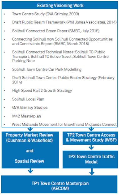
147. In 2016 SMBC commissioned the development of a Town Centre Masterplan which would provide a blueprint for future investment and development which maximises the opportunities for Solihull Town Centre, capitalises on its existing assets, and sets out a clear vision for Solihull 2036; as a vibrant, sustainable, aspirational and diverse 21st century town. The masterplan has been informed by the findings and proposals of a number of previous and concurrently run studies. These studies and the inter-relationship between them are shown below:
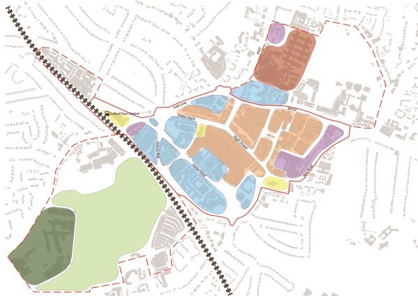
148. The evidence base that supports the masterplan has been informed by discussions and engagement with a wide range of town centre stakeholders through one on one, and group workshop sessions. The proposals of the draft masterplan have been presented for public consultation during August and September 2016, and the responses have helped inform the development of the final preferred masterplan. This draft masterplan has helped shape the proposals of the town centre policy. The centre is contained within clearly defined boundaries, the Chiltern railway and Prince's Way to the south-west, Blossomfield Road, Lode Lane to the north-west, Warwick Road to the north, New Road and Churchill Road to the east.
149. Near the centre, to the west, is Solihull railway station and to the south and east Tudor Grange and Malvern Parks respectively. The High street is an important principal pedestrian route through the centre providing pedestrian links to the modern Touchwood shopping mall on the south side and to the older Mell Square precinct to the North. It also links the Poplar Road bus interchange area in the direction of the railway station with St Alphege Church and the attractive historic core along the High Street.
150. The Town Centre is an appropriate location for a broad range of town centre uses including retail, leisure and entertainment facilities, appropriate sport and recreation uses, offices, arts, culture and tourism and residential. It is important that opportunities for development improve the centre, adding to vitality and vibrancy, whilst retaining or enhancing important characteristics.
151. High quality urban design will therefore be expected to ensure that development will protect the character of the Centre's historic heritage, improve public realm and improve pedestrian movement around the centre, for example, to improve links to the Centre's parks and provide improved articulation between Touchwood and nearby open spaces and improve the pedestrian link between Mell Square and the Warwick Road Morrison's store which has poor public realm. Design principles that developers will be expected to follow are identified in the policy.
152. The timing of development will maintain a balance of activity throughout the centre over the Plan period and to ensure continued success either side of the High Street and to fit with provision of new infrastructure, including public transport improvements and traffic management measures. The area to the south of the High Street has been the focus of activity in more recent times, with the development of Touchwood and current proposals for its extension and the recently opened Waitrose store, but parts of the Centre are becoming outdated in appearance and would benefit from new development to modernise it and increase its attraction.
Illustrative Master Plan:
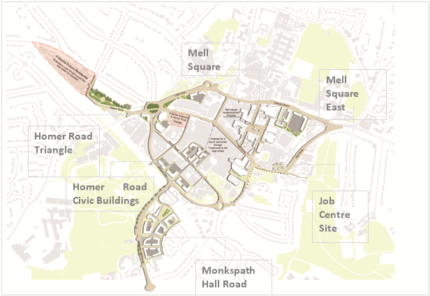
153. The Illustrative Town Centre Masterplan Diagram a number of opportunity sites where development has the potential to come forward within the period of the local plan and beyond. The sites represent the opportunity to improve the attractiveness of the Centre as a place of quality and distinction reflecting strong urban design principles.
154. The sites are identified in the Town Centre Masterplan 2016-2036 which was informed by a market review carried out in 2016 by Cushman and Wakefield which found that:
- There is latent demand for office space in the town centre, especially for 'headquarter style' offices characterised by large floorplates which efficiently serve the operational requirements of the occupier.
- There is continued market interest in apartment buildings with well-located apartments comfortably achieving values which would make the provision of one floor of basement parking viable, which has the potential to impact on achievable development densities.
- The retail function of the town centre should be strengthened through the introduction and addition of complementary town centre uses in appropriate places with new office and residential development playing an important role in increasing visits and use of the town centre as a whole.
155. The level and type of development identified for each site has been developed as an urban design response in the first instance, and then tested through an iterative review which considered the capacity, deliverability and viability of each site. The masterplan evidence base confirms that in broad terms these sites could support the level of residential development indicated in mixed and standalone developments, and that there would be capacity for the level of retail and office development indicated:
- Residential – up to 860 new homes within the town centre. The masterplan identifies the capacity to deliver up to 1,400 new homes, however a cautious approach has been taken and only capacity on those sites where there is a reasonable level of confidence that they will be delivered within the plan period have been included in this number
- Office – up to 74,620m2 of new office development
- Commercial and Leisure – up to 11,700m2 of new commercial and leisure development.
156. A diverse evening economy can help shape the attraction of the Town Centre as a place that is vibrant and inclusive. The Council will encourage, through the development management process, a broad age spectrum of residents into the centre to enjoy a wide variety of leisure and entertainment facilities.
157. The scale of the changes envisaged for Solihull Town Centre will inevitably take some time to realise and will be realised gradually throughout the life of the plan, and beyond. The timescales within which the opportunity sites are delivered will be influenced by a range of factors, including land ownership, predicted longevity of existing uses and market conditions. Sites already in public ownership or currently being considered for development are likely to come forward in the short term, and will need to be supported by upgrades to the public realm and connectivity. This will help to create a setting for investment in large scale developments in the medium to long term, on sites outside public ownership or with more complex land assembly requirements. There is also the opportunity to bring forward developments in support of Policy P9 (Mitigating and Adapting to Climate Change), particularly through district energy and/or heat networks.
|
Solihull Town Centre Masterplan Opportunity Sites |
|
Monkspath Hall Road Design Principles: •Located just south of the town centre and adjacent to Tudor Grange Park, Monkspath Hall Road Car Park represents a strategically significant opportunity to accommodate a relocated train station, and substantial new development, within a few minutes' walk of the town centre. •A relocated train station could span the railway line providing easy access between a new civic square and associated development to the south and the town centre to the north. •A new multi-storey would provide car parking for commuters and visitors, and the creation of a new transport interchange would ensure a linked public transport system for Solihull. •The creation of a new civic square would be complemented by surrounding commercial development which could enhance the user experience by providing places to eat, drink and browse overlooking the square. •There is opportunity to provide family housing to the south of the site, which could come forward prior to the station relocation, with higher density residential development coming forward and infilling around the station once it has been relocated. Potential capacity and preferred use for the site: •Up to 1,900m2 of leisure / commercial uses •A new multi-storey car park providing up to 950 spaces •Up to 398 new high density homes (to the north) incorporating up to 398 basement car parking spaces •Up to 54 new medium density family homes (to the south) incorporating on plot parking •Relocated train station and transport interchange Homer Road Triangle Design Principles: •Located on Lode Lane/ Blossomfield Road roundabout, Homer Road Triangle is situated on a prominent gateway into the town centre and provides opportunity to create an attractive new arrival point into Solihull's business and commercial quarter. •Development should deliver new 'Grade A' offices providing larger floorplate 'headquarter type space' particularly on the corner affronting the Blossomfield Road, Lode Lane, Princes Way Roundabout, to emphasise the scale and prominence of the development. •Development should include enhancements to the public realm around Lode Lane/Blossomfield Road roundabout which improve pedestrian connectivity and provide an attractive setting for new development. The potential capacity and preferred use for the site: •Up to 32,320m2 of new office development •Accommodated on buildings between four and six storeys in height •Up to 497 surface car parking spaces to serve the development Homer Road Civic Buildings Design Principles •Situated along Homer Road in the heart of the business and commercial area of the town centre, this site provides the opportunity for large scale redevelopment, if the police station were to be relocated and developed along with the Magistrates Court which is currently being marketed •Development of this site could strengthen Solihull's current residential offer integrating new urban living opportunities to create a vibrant mixed use area. This combination of living and working uses will breathe life into the area beyond traditional office hours. •Development of the site also provides a key opportunity to create a north-south pedestrian and cycle link between Touchwood and Homer Road, which in the long term could be extended to Princes Way and the station if it were to be relocated. The potential capacity and preferred use for the site are: •Up to 226 new homes •Accommodated on buildings approximately 4-6 stories in height •Up to 226 basement car parking spaces to serve the development Mell Square East Design Principles: •Forming the north eastern edge of the town centre and fronting Warwick Road, this prominent site has the long term potential to accommodate large scale redevelopment for high density urban living. •Providing attractive new frontage onto Warwick Road, new residential development should present an opportunity to enhance the existing public realm and tie in with future Mell Square proposals to improve pedestrian connectivity. •There are opportunities to bring forward the site in stages to align with when sites become available, however it will be important to ensure that the overall development has a common character and links together. •The masterplan identifies additional capacity in this site to deliver further residential development in future phases. The potential capacity and preferred use for the site are: •Up to 123 new homes •Accommodated on buildings up to five storeys in height •Up to 123 car parking spaces (mixture of surface and basement) to serve the development Mell Square Design Principles •Development of Mell Square should seek to create a retail loop encompassing Touchwood, High street, Drury lane, Mell Square, Mill lane to complete the town centre shopping experience; •Development should uplift the identity of the area establishing it as a destination, with increased dwell time attracting and high quality retailers and restaurateurs. •Development should maximise pedestrian linkages and views to Warwick Road and Poplar Road by direct, attractive and active routes and should open up opportunities to improve pedestrian linkages to Mell Square East •Development will create a legible and attractive environment for visitors through the scale and massing of buildings to the detailing of the landscaping, street furniture and signage. •Development should provide the right environment to support high quality new apartment living in the Square. The preferred use for the site is includes: •Elements of retail, offices, civic accommodation and high density residential accommodation, with the potential capacity to deliver 147 new homes. Job Centre Site Design principles •Located within the historic St Alphege Quarter, the job centre site has the potential to accommodate comprehensive future redevelopment. •New development would provide an attractive frontage onto New Road, providing an attractive entrance to the heart of the town centre. •Development should sit sensitively within the existing historical and characterful context of the area and provide similar typologies to those that already exist along New Road. The preferred use for the site is:
|
158. The following table indicates potential phasing[17]:
|
Site and Indicative Phasing |
Estimated Capacity |
|
Short Term (0-5 years) Homer Road Mell Square Monkspath Hall Road (Low density element) |
226 147 54 |
|
Medium Term (5-10 years) Job Centre Site |
11 |
|
Long Term (10-15 years) Monkspath Hall Road (medium) Mell Square East |
300[18] 123 |
|
Total Potential Capacity |
861 |
Justification - Shirley Town Centre
159. Shirley Town Centre is the Borough's second largest shopping centre and an important centre for commercial activity and services to a broad local catchment. The Centre faces competition from nearby out of centre retailing in the A34 corridor and from increased offer in Solihull Town Centre. It is a long, linear centre arranged either side of the A34, with a number of foodstores anchoring mini-clusters. It has a variety of convenience and comparison goods retailers and continues to maintain its vitality and viability.
160. The Centre lacked a substantial retail core that will help to provide a 'heart' for the Centre that could strengthen its competitive position. To remedy this weakness a mixed use scheme (known as Parkgate) anchored by a food-based superstore, and including a variety of comparison retail units designed to meet modern retailer requirements and residential accommodation, was developed and is now trading. The scheme also improves links to Shirley Park as an important local amenity that improves the attractiveness of the Centre to shoppers.
161. Near to the Town Centre on the corner of Haslucks Green Road and Stratford road is the former Powergen offices site. The site has been vacant for well over a decade but the development of Parkgate has stimulated interest in its development and permission has now been granted for a largely residential scheme.
162. Nationally, the traditional high street faces numerous strategic challenges, including the growth of on-line retailing in particular. Consequently, there is a need for town centres to reinvent themselves as places to visit, with attractive public realm, open spaces and core retail offer supported by a mix of civic and leisure facilities. Interest has been expressed by businesses within the town centre to explore the feasibility of establishing a Business Improvement District (BID) to address the strategic challenges. This will be considered through an economic plan for Shirley, which the Council will prepare.
Justification - Chelmsley Wood Town Centre
163. Chelmsley Wood Town Centre is the main centre for North Solihull and is an important centre of commercial activity and services and for its public transport accessibility. The main part is a purpose built precinct that opened in 1971 to serve the Birmingham overspill estates that are now part of North Solihull. The performance of the Centre deteriorated between 1998 and 2006 but then improved following increased investment in and management of the Centre. The Centre is anchored by a recently constructed food-based superstore that is part of other improvements that have included a new library, housing/social services offices, bus interchange and public realm improvements. Further limited comparison retail development is also included. New development can bring opportunities to strengthen the role of the Centre in serving the community by improving links to North Solihull and to nearby open spaces.
Challenges and Objectives Addressed by the Policy
A Reducing inequalities in the Borough
B Meeting housing needs across the Borough, including the Borough's own needs and, where possible, assisting with accommodating the HMA wide shortfall.
C Sustaining the attractiveness of the Borough for people who live, work and invest in Solihull
D Securing sustainable economic growth
F Climate change
H Increasing accessibility and encouraging sustainable travel
J Improving health and well being
(81) 7. Do you agree with Policy P2? If not why not, and what alternative would you suggest?
(35) 8. Do you believe the right scale and location of development has been identified? If not why not?
|
Policy P3 Provision of Land for General Business and Premises |
|
To encourage sustainable economic growth and provide a broad range of employment opportunities the Council will plan for a continuing supply of employment land. The table below identifies the strategic sites that comprise the Council's supply of main employment land for this purpose, adopting a plan monitor and manage approach to avoid over allocating land that may lead to unnecessary loss of Green Belt. The Council will support the allocated sites for purposes set out in the table. Small-scale supporting facilities may be allowed where needed to specifically enhance or complement business use in the particular business locality and are compatible with sustainable development principles. To ensure that an adequate supply of land remains available for employment purposes, sites will be protected for their allocated purposes. Non-allocated employment sites will also be protected for employment use (Classes B1, B2, B8 and, where appropriate, waste management). Alternative uses may be allowed where the following criteria are met: •The site is relatively isolated from other business premises or is out of place in the context of other neighbouring uses, such as residential; or •It is clearly demonstrated that there is no longer a need to retain the site/premises for their intended business class purpose; or •In the case of vacant premises, there is no longer a reasonable prospect of attracting business development in market terms; •The alternative use will support sustainable development principles and will directly support employment locally; •There is no conflict with other policies of the Local Plan or National Planning Policy. The Council will encourage the retention of small and medium sized enterprises, and the creation of new ones, both in urban and rural areas as a key economic driver and to help facilitate growth in a broad variety of locations, including North Solihull as a priority, subject to the following criteria: •Form, use and scale are appropriate to the character of the particular location. •There is no significant harm to the local environment, including landscape quality and character. •Proposals for home-working are compatible with the character of the local environment and are consistent with the amenity policies of the Local Plan. •The land or premises are not in the Green Belt or are compliant with Green Belt policy. •In the case of development in rural areas, it is consistent with the Council's countryside policies and does not undermine the quality and character of the natural environment. The Council will expect development proposals on business sites to include the necessary infrastructure to accommodate high capacity digital communication. In order to encourage sustainable access to business developments and reduce the need to travel, applicants for planning permission for business use will be expected to demonstrate the anticipated level of employment that will be generated and how this will be of benefit to meet local employment needs. Employment development will not be allowed where it sterilises natural resources or key sites needed to secure sustainable development, particularly in regard to provision for distributed heat and energy networks. |
Justification
164. The Borough is home to a number of business sites of more local significance of varying age and quality. These are important for local employment opportunities to provide a broad range of business accommodation in terms of type and size and a number of them have land that remains to be developed, for instance Fore . Other older sites, such as Cranmore Industrial Estate, Boulton Road and Elmdon Trading Estate, provide some further opportunities through redevelopment of older outmoded premises.
165. The table below includes existing allocations to be carried forward from the SLP and new allocations. Although these new allocations have come forward in support of Policy P1, they are included here for completeness.
Site |
Site no[19]. |
Available allocated area (ha) |
Readily available allocated area (ha) |
Preferred Use Classes |
Blythe Valley Business Park |
SLP 10 |
See footnote[20] |
|
B1, B2, B8 |
TRW/The Green, Stratford Road, Shirley |
SLP 25 |
18.5[21] |
18.521 |
B1, B2, B8 |
Fore, Stratford Road, adj M42 |
SLP27 |
2.0 |
2.0 |
B1 |
Chep/Higginson, Bickenhill Lane, Bickenhill |
SLP 28 |
4.0 |
0.0 |
B1, B2, B8 |
Land north of Clock Interchange, Coventry Road |
SLP 29 |
2.0 |
1.0 |
B1 |
Land adj Birmingham Business Park |
SLP 31 |
9.0 |
9.0 |
B1, B2, B8 |
Land at HS2 Interchange |
LPR 19 |
c140 |
|
See Policy P1 |
Land at Damson Parkway |
LPR 20 |
c94[22] |
|
See Policy P1 |
166. Allocated provision comprises land remaining to be developed on existing employment sites. The evidence base supports the approach of using existing allocations with a broad range of employment uses where possible so that there is less reliance on the B1 use class. This is supported by market trends that show a preference for town centres as office locations.
167. The above table also includes two allocations (LPR 19 & 20) which will necessitate land to be removed from the Green Belt. The justification for Policy P1 provides the exceptional circumstances for this approach.
168. In addition to the allocated employment sites, Solihull has a number of employment sites where opportunities to recycle employment land may come forward. For example, substantial recycling of land has already occurred in older premises at Cranmore Industrial Estate (Monkspath) to create new offices and modern industrial/warehouse units and similar opportunities may come forward elsewhere, such as within Elmdon Trading Estate (near the Airport).
169. Birmingham and Blythe Valley Business Parks have about 29[23] hectares remaining to be developed. This should be sufficient land for the plan period. The evidence base suggests average annual take up 2001-2016 has been about 1.6ha on these sites collectively. However, this may increase as a result of enabling a broader range of development.
170. For the purposes of the Local Plan employment uses are business class uses and appropriate waste management facilities. Planning applications for waste management facilities will be considered in the context of effects on local environment and amenity both within the employment site and its broader surroundings and the nature of waste management operation, for example, the extent that it takes place within the confines of a building, the amenity and traffic or transport effects on the road network and effects on pollution.
171. Solihull does not have substantial amounts of previously developed land that would be suitable or available for employment purposes. It is therefore important to protect the limited supply of employment land and premises from alternative uses, including types of economic development that would be more appropriate in a town centre environment.
172. The policy sets out the particular circumstances when alternative development may be accepted. These include, for example, small isolated premises in predominantly residential surroundings that render the premises out of context and better able to support sustainable development principles in an alternative use.
173. Mixed business uses may be enabled on employment sites where this will help to support sustainable development principles. Business class uses should predominate. Other uses of an ancillary nature may be enabled provided they are small scale in the context of the mixed use development and justified in terms of supporting the business function of the mixed use development and do not conflict with National Planning Policy, particularly in regard to its aims of supporting sustainable economic development and growth and supporting town centres.
174. Small and medium sized enterprises will be encouraged in all areas of the Borough, including rural areas, North Solihull and within established business sites, through redevelopment and creation of other opportunities for the development of small business space, provided they meet the criteria in the Policy that seek to protect the environment, local amenity and the Green Belt.
175. Digital connectivity and high capacity communication networks are key to commercial success in the 21st Century. Solihull is committed to increasing digital capacity across the Borough to help in remaining competitive, attracting inward investment, reducing inequalities and remaining a leading centre of enterprise.
Challenges and Objectives Addressed by the Policy
A Reducing inequalities in the Borough
C Sustaining the attractiveness of the Borough for people who live, work and invest in Solihull
D Securing sustainable economic growth
F Climate change
HIncreasing accessibility and encouraging sustainable travel
J Improving health and well being
(54) 9. Do you agree with Policy P3? If not why not, and what alternative would you suggest?
(37) 10. Do you believe the right scale and location of development has been identified? If not why not?
[14] The parkway station is the design in the HS2 Bill, but through a change control process, an alternative design for the rail and station infrastructure is being pursued that would allow the wider, none rail related, development to be accommodated in line with the visions and strategies set out.
[15] As the Airport update the masterplan, the local plan review will need to respond accordingly.
[16] Through the Gypsy and Traveller Site Allocations Plan.
[17] For purposes of housing land supply, a more cautious approach will be assumed to the delivery of the sites indicated in the short term and it will be assumed they won't be delivered until years 5-10.
[18] Based on the train station remaining in current location freeing up land earmarked for its relocation for delivery as medium density housing. If the station was to be relocated to this site, higher density units would be appropriate and up to an additional 99 homes could be delivered.
[19] SLP references refer to the numbers given to the sites in the SLP.
[20] The current planning application for the site proposes B1/B2/B8 development of between 59,000 sqm and 99,000 sqm to come forward as part of a mixed use scheme
[21] This represents the area available identified though the SLP, but through this local plan review this will be reduced to accommodate the residential allocation detailed in a later chapter. Once a concept masterplan has been developed for the next iteration of the plan, it will be clearer how much employment floorspace can be accommodated on the site as part of a mixed use scheme.
[22] For all of this area to be available it will be necessary to demonstrate that the sport/recreational uses on the wider area are either surplus or can be re-provided elsewhere.
[23] Including the expansion land at BBP allocated under the SLP, but excluding land to be used for housing at BVP.