Draft Local Plan Review
C. Schedule of Allocated Housing Sites
|
LPR Ref (SHELAA Refs[41]) |
Site Name |
Area |
Green Belt |
Site Area (ha) |
Site Capacity[42] |
Delivery years |
Site constraints |
Reasons and Conditions |
Likely Infrastructure Requirements |
||
|
1-5 |
6-10 |
11-15 |
|||||||||
|
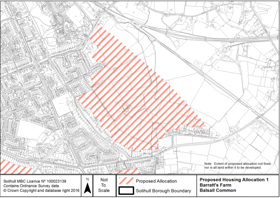
1 (1002 – inc. 33 & 102; and 1016 – inc. 30, 196 & 236)[43] |
Barratt's Farm |
Balsall Common |
Yes |
57 |
800 |
|
|
|
Includes existing park. Listed buildings to edge of site. Area of search for coal. |
Scores better in accessibility terms than western edge of Balsall Common due to proximity to railway station and access to main town centre services. Cumulative Green Belt score of 5, compared to 7 along north-western edge. Need to respect historic setting of listed buildings. Excludes area of Flood Zones 2 and 3 in SHELAA Ref. 33. Coal is deep underground resource that is unlikely to be affected by surface development in this location. |
Integrate highway access with Station Road. Highway capacity improvements at Station Road and junction with A452. Improvement to passenger waiting facilities at Berkswell Station. Requires multiple points of vehicular access. Potential for bypass line. Pedestrian and cycling connectivity enhancements towards Balsall Common centre and Berkswell train station. Bus service improvements. Provision of, or contribution to, existing play area/parks and open space. Integration of green infrastructure connectivity with wider countryside and LWS to south of Waste Lane. Increased primary and secondary school provision or new school. SUDs. Local healthcare facilities. 50% affordable housing. |
|
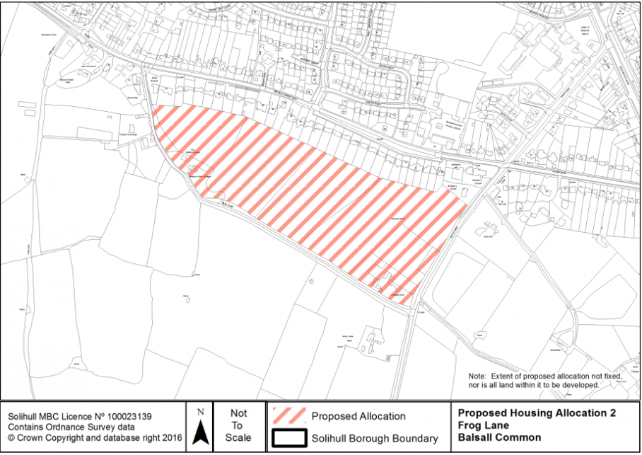
2 (75)[44] |
Frog Lane |
Balsall Common |
Yes |
6 |
150 |
|
|
|
Holly Lane allotments. Listed building at Cottage farm. Listed buildings adjacent to north-west of site at Frogmore Grange and Stables at Frogmore Grange. Area of search for coal. |
Cumulative Green Belt score of 5. Generally accessible, but lower for GPs. The proposed allocation would position the Green Belt boundary on Holly Lane so that it is forms a defensible boundary. The allotments and listed building are not proposed for redevelopment. Coal is deep underground resource that is unlikely to be affected by surface development in this location. |
Highway and access improvements at Balsall Street East and at Frog Lane/Balsall Street East junction, including possible road widening of Frog Lane. Pedestrian and cycling connectivity enhancements towards Balsall Common. Bus service improvements and primary school and village centre. Provision of, or contribution to, existing play area/parks and open space. Integration of green infrastructure connectivity with wider countryside. Preservation of significance of historic setting of listed building. Increased primary and secondary school provision. SUDs. Local healthcare facilities. 50% affordable housing. |
|
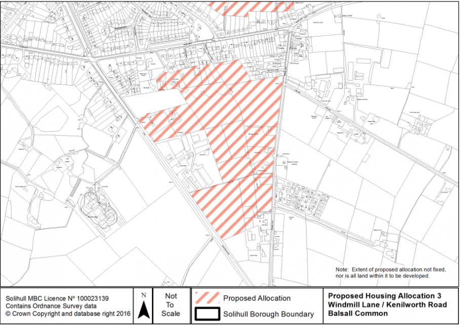
3 (47, 138)[45] |
Windmill Lane/ Kenilworth Road |
Balsall Common |
Yes |
11 |
200 |
|
|
|
Area of search for coal. Listed building to east of site, 'The Windmill'. |
Cumulative Green Belt score of 4. Generally accessible for bus services and primary school, but lower for fresh food and GPs. Coal is deep underground resource that is unlikely to be affected by surface development in this location. |
Highway, access and capacity improvements on Kenilworth Road, A452. Pedestrian and cycling connectivity enhancements towards Balsall Common. Bus service improvements and primary school and village centre. Possible secondary access on Windmill Lane. Provision of, or contribution to, existing play area/parks and open space. Integration of green infrastructure connectivity with wider countryside. Increased primary and secondary school provision. SUDs. Local healthcare facilities. 50% affordable housing. |
|
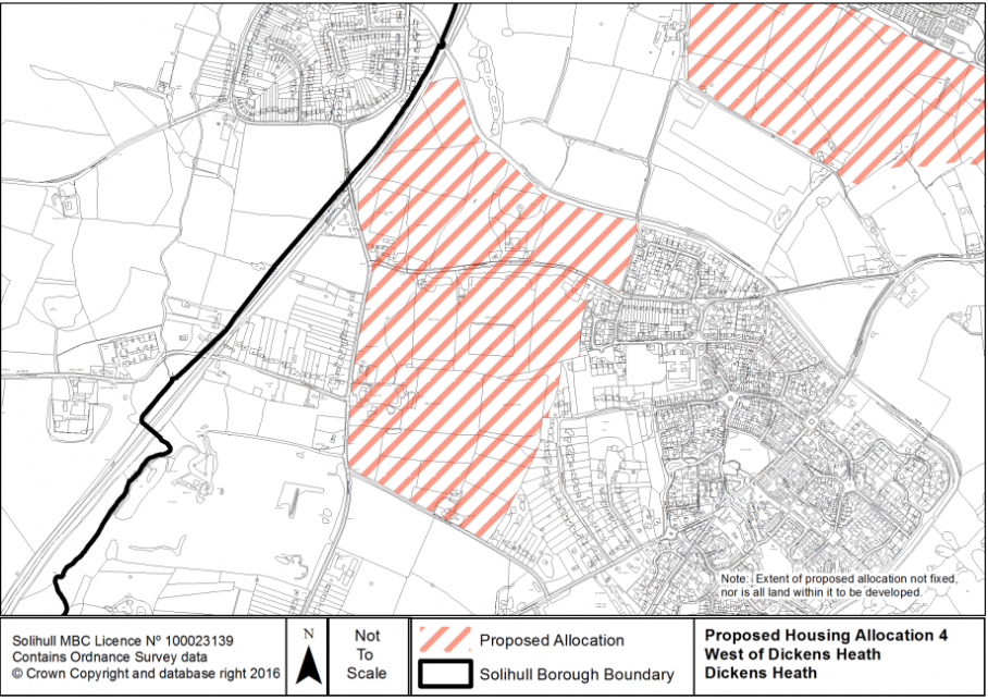
4 (126, 130 & 176)[46] |
West of Dickens Heath (off Tythe Barn Lane, Tilehouse Lane & Birchy Leasowes Lane) |
Dickens Heath |
Yes |
41 |
700 |
|
|
|
Little Tyburn Coppice LWS. Tythe Barn Lane Meadows LWS. Existing sports pitches & football club. |
Defensible Green Belt boundary of Birchy Leasowes Lane to south, Tilehouse Lane to west, railway line to west and canal to north. Cumulative Green Belt score of 7, with section of 8 to north of site. Little Tyburn Coppice to be retained as a Local Wildlife Site. No net loss of biodiversity for meadows. Area between railway line and west of Tilehouse Lane scores less well in Green Belt terms, but includes station car park and existing ribbon development. Accessible to train station; accessibility to other services would be improved as a result of development. |
Replacement of existing sport pitches provision if not in surplus. Highway widening, capacity and access improvements along Tythe Barn Lane and Tythe Barn Lane/Tilehouse Lane junction. Requires primary and secondary points of vehicular access. Pedestrian and cycling connectivity improvements to Whitlocks End Station and Dickens Heath local centre. Bus service improvements. Increased primary & secondary school provision. Local healthcare facilities. Green infrastructure connectivity through the site and with wider countryside. Provision of play area and community access to existing natural green space and open space within site boundaries. 50% affordable housing. |
|
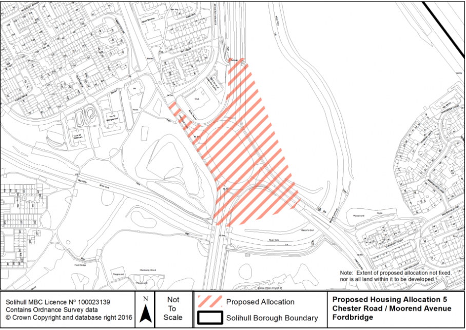
5 (52)[47] |
Chester Road/ Moorend Avenue |
Fordbridge |
Yes |
4 |
100 |
|
|
|
Viability. Remodelling of road junction. |
Regeneration of North Solihull. Highly accessible location. Cumulative GB score of 7 to the east and 2 to the south and west. |
Remodelling of road junction. Vehicular and pedestrian access. Pedestrian and cycling connectivity. Provision of, or contribution to, existing play area/parks and open space. Green Infrastructure connectivity with adjacent Cole Bank Park LWS. SUDs. Local healthcare facilities. 50% affordable housing. |
|
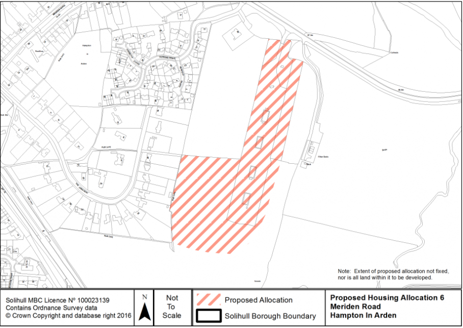
6 (117 & 129)[48] |
Meriden Road |
Hampton-in-Arden |
Yes |
7 |
100 |
|
|
|
Existing green space site allocation within Local Plan. |
Adjacent to existing housing site within the Local Plan and includes brownfield land that the local Parish Council would like to see regenerated. Part of site has been designated as a green space site, should housing development come forward on existing allocated site. Would result in small rounding off of settlement and would not encroach into wider countryside. Cumulative Green Belt score of 5, compared with 12 for the Broad area between Hampton-in-Arden and Meriden. |
Highway speed reduction and access improvements along Meriden Road. Pedestrian and cycling connectivity enhancements towards Hampton village centre and train station. Provision of, or contribution to, existing play area/parks and open space, especially important given existing designations in SLP. Potential for comprehensive approach in conjunction with existing SLP allocation. Increased primary and secondary school provision. SUDs. Potential contribution to existing local healthcare facilities. 50% affordable housing. |
|
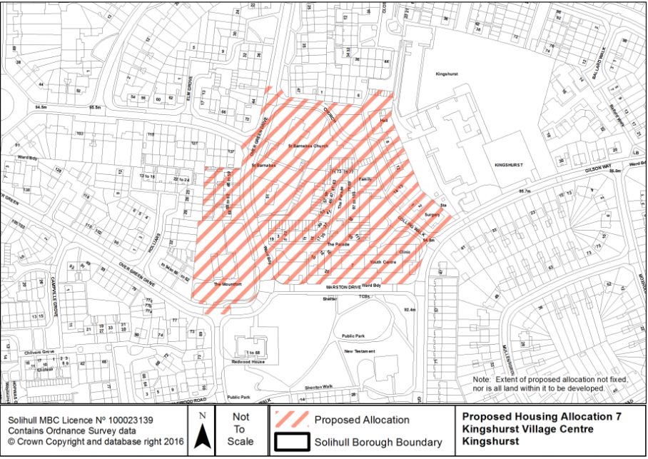
7 (229)[49] |
Kingshurst Village Centre |
Kingshurst |
No |
4 |
100 |
|
|
|
Viability. Demolitions required. |
Re-use of previously developed land. Regeneration of North Solihull. Highly accessible location. |
Vehicular and pedestrian access improvements. Pedestrian and cycling connectivity. Provision of, or contribution to, existing play area/parks and open space. SUDs. Local healthcare facilities. 50% affordable housing. |
|
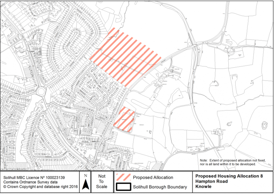
8 (166 & 213)[50] |
Hampton Road |
Knowle |
Yes |
13 |
300 |
|
|
|
Purnell's brook. Existing playing pitches. Small portion of northern site is a Local Wildlife Site. Historic setting of Knowle Conservation Area. |
Split site. Northern section has a cumulative Green Belt score of 7 and southern section of 11. The eastern edge of Knowle, Dorridge & Bentley Heath (KDBH), which adjoins more open countryside, scores more highly overall than the western edge, which has more urbanising influences and ribbon development. However, the western edge separates the main Solihull conurbation from the villages of KDBH and prevents merging of these distinct localities. Furthermore, the River Blythe SSSI winds through this gap, with resulting large areas of floodplain and biodiversity interest, which form an important green and blue corridor. In accessibility terms, the sites also score more highly than those on the western edge of KDBH, due to proximity to services in Knowle village centre. The southern section scores highly in Green Belt terms due to views into Knowle Conservation Area, and responding to the historic setting of KCA would be a key factor in lay-out and design. |
Speed reduction and access improvements along Hampton Road. Highway capacity improvements at A4141 junction. Replacement playing pitch provision, required on or off-site. Pedestrian and cycling connectivity enhancements towards Knowle local centre. Potential canal towpath improvements. Provision of, or contribution to, existing play area/parks and open space. Retain green infrastructure connectivity within site and links to wider countryside. Increased primary and secondary school provision. SUDs. Local healthcare facilities. 50% affordable housing. |
|
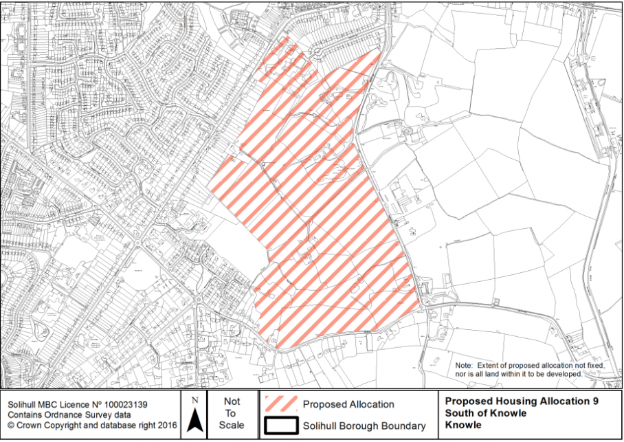
9 (1010, inc. 148, 149, 151, 152, 153, 154 & 156)[51] |
South of Knowle (between Station Road, Warwick Road and Grove Road) |
Knowle |
Yes |
46 |
750 |
|
|
|
Arden Academy on constrained site. Existing pond. Cuttle brook. Potential Local Wildlife Site through southern part of site. |
Cumulative Green Belt score of 5. Defensible Green Belt boundary along A4141 and Grove Road. Make best use of existing green infrastructure and biodiversity assets; to retain rural fringe character along boundary roads. Avoids intrusion into Knowle Conservation Area. Respect landscape character and historic setting of listed buildings to south of site. Accessible to Knowle and Dorridge local centres; accessibility to services would be improved as a result of development. |
Highway capacity and access improvements along A4141 & B4101. Requires multiple points of vehicular access. Increased primary and secondary school provision; submitted scheme includes replacement secondary school. Pedestrian and cycling connectivity enhancements towards Knowle and Dorridge local centre, and across site to replacement school. Provision of play area and open space, making best use of existing green and blue infrastructure assets. Community access to school facilities out of hours, such as playing pitches. SUDs. Local healthcare facilities. 50% affordable housing. |
|
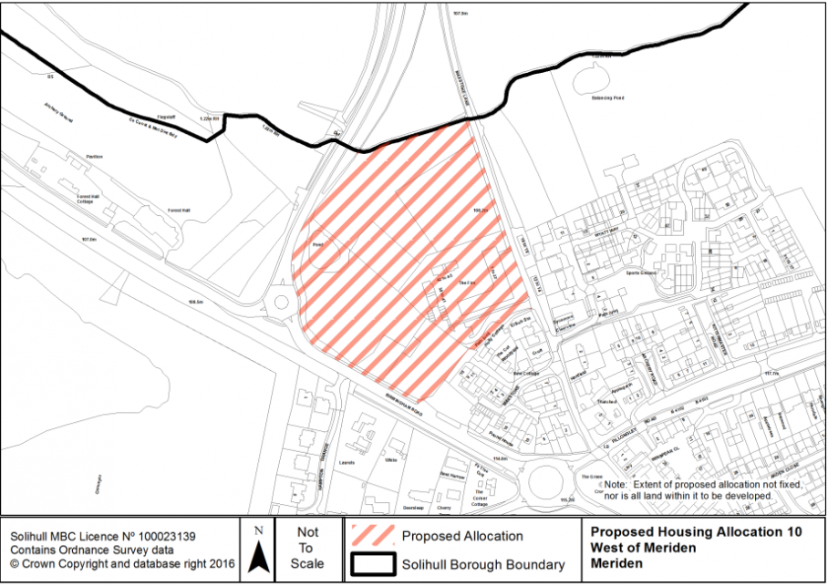
10 (119 & 137)[52] |
West of Meriden (between Birmingham Road and Maxstoke Lane) |
Meriden |
Yes |
3 |
50 |
|
|
|
Area of search for coal. |
Cumulative GB score of 5. Addresses local housing need including higher proportion of affordable housing. Accessible location. Coal is deep underground resource that is unlikely to be affected by surface development in this location. Some existing built development present. |
Access to site in comprehensive manner. Provision of, or contribution to, existing play area/parks and open space. Potential increased primary and secondary school provision. 50+% affordable housing. |
|
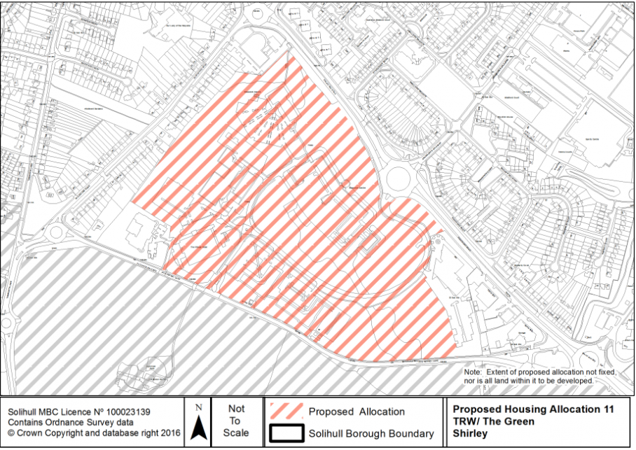
11 (124)[53] |
TRW/The Green (Stratford Road) |
Shirley |
No |
19 |
400 |
|
|
|
Site is currently allocated for B1, B2 and B8 employment land. TPOs. |
Re-use of previously developed land. Site promoter reports that no substantive market interest for office development since 2005. Potential to use part of site for complementary mixed use retail/leisure development. Highly accessible location. |
Vehicular and pedestrian access improvements. Pedestrian and cycling connectivity enhancements towards Stratford Road to east and proposed allocation to south of Shirley. Primary and secondary school places provision, dependent on scale and phasing with other allocations. Provision of, or contribution to, existing play area/parks and open space. TPOs to be retained where appropriate. SUDs. Local healthcare facilities. 50% affordable housing. |
|
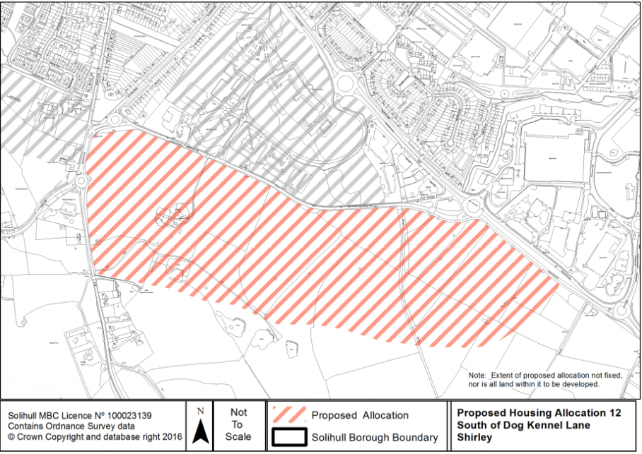
12 (122 - included in 1007)[54] |
South of Dog Kennel Lane |
Shirley |
Yes |
42 |
850 |
|
|
|
Ponds and small area of Flood Zones 2&3 to south-west of site. |
Defensible Green Belt boundary along field edges. Cumulative Green Belt score of 6. Retains Green Belt buffer between surrounding countryside and Cheswick Green settlement. Respect historic setting of listed building at Light Hall Farm. Avoids building on the Flood Zones. Retains landscape character to the south of site. Proposed urban extension would sit in valley of site and be less visually prominent. Accessibility to services would be improved as a result of development. |
Integrating new highway with proposed development at West of Dickens Heath on B4102 and Dog Kennel Lane. Possible capacity enhancement to A34. Requires multiple points of vehicular access. Pedestrian and cycling connectivity enhancements to Shirley South, especially Tanworth Lane and integration with proposed residential development at TRW/The Green site. Increased primary & secondary school provision. Provision of play area and open space, making best use of existing green and blue infrastructure assets. Bus service improvements. Local healthcare facilities. Green infrastructure. 50% affordable housing. |
|
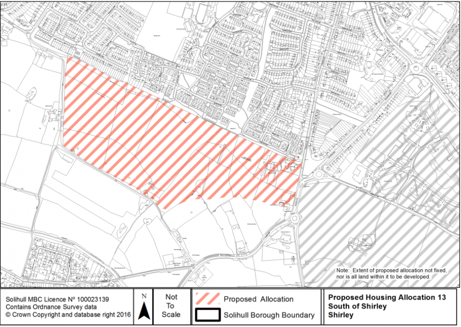
13 (part-41 & 223)[55] |
South of Shirley (between Whitlocks End Farm and Dickens Heath Road) |
Shirley |
Yes |
30 |
600 |
|
|
|
Christmas tree farm. Access into and across site. |
Defensible Green Belt boundary along field edges Cumulative Green Belt score of 6. Retains Green Belt buffer between surrounding countryside and Stratford on Avon canal. Accessibility to services would be improved as a result of development. |
Integrating new highway and access from B4102 including capacity improvements. Possible capacity enhancements to A34. Requires primary and secondary points of vehicular access. Pedestrian and cycling connectivity to Shirley South, especially Light Hall School. Increased primary & secondary school provision. Bus service improvements. Local healthcare facilities. Green infrastructure connectivity to be retained and enhanced within the site as well as links to wider countryside. 50% affordable housing |
|
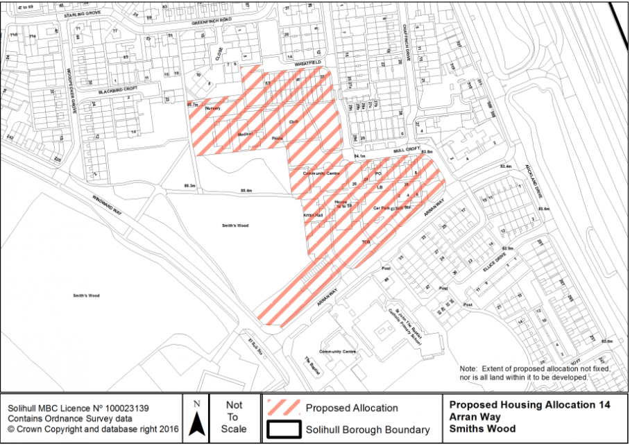
14 (50)[56] |
Arran Way |
Smith's Wood |
No |
2 |
50 |
|
|
|
Viability. |
Re-use of previously developed land. Regeneration of North Solihull. Highly accessible location. |
Vehicular and pedestrian access improvements. Pedestrian and cycling connectivity Provision of, or contribution to, existing play area/parks and open space. Green infrastructure connectivity with adjacent open space and LWS/LNR. SUDs. Potential enhancement to local healthcare facilities. 50% affordable housing. |
|
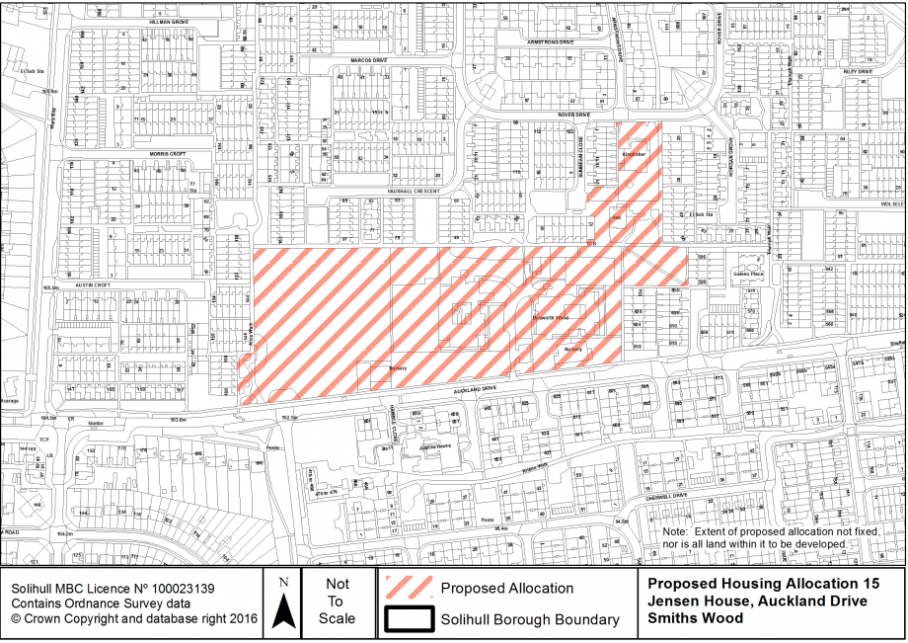
15 (51)[57] |
Jensen House/ Auckland Drive |
Smith's Wood |
No |
4 |
100 |
|
|
|
Viability. |
Re-use of previously developed land. Regeneration of North Solihull. Highly accessible location. |
Vehicular and pedestrian access improvements. Pedestrian and cycling connectivity Provision of, or contribution to, existing play area/parks and open space. SUDs. Potential enhancement to local healthcare facilities. 50% affordable housing. |
|
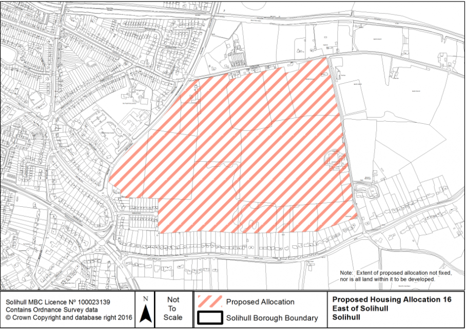
16 (11 & 1009, which includes 15, 67, 147, 230)[58] |
East of Solihull (between Lugtrout Lane and Hampton Lane) |
Solihull |
Yes |
39 |
650 |
|
|
|
Listed building at Field Farmhouse on eastern edge of site. |
Relatively low cumulative Green Belt score of 4, with defensible boundaries along Hampton Lane, Lugtrout Lane and Field Lane. The west and northern part of the site, bordering Damson Parkway and Lugtrout Lane score better in accessibility terms than the southern part of the site adjoining Hampton Lane. Site is close to main town centre. Preservation of significance of historic setting of listed building. |
Highway and access improvements along Lugtrout Lane, Damson Parkway & Hampton Road with possible road widening of Field Lane. Requires multiple points of vehicular access Capacity enhancements at A41/Hampton Lane/Marsh Lane/Yew Tree Lane junction. Pedestrian and cycling connectivity improvements towards Solihull town centre local centre. Provision of, or contribution to, existing play area/parks and open space. Green infrastructure connectivity within the site to be integrated as well as links created with wider countryside. Increased primary and secondary school provision. SUDs. Local healthcare facilities. 50% affordable housing. |
|
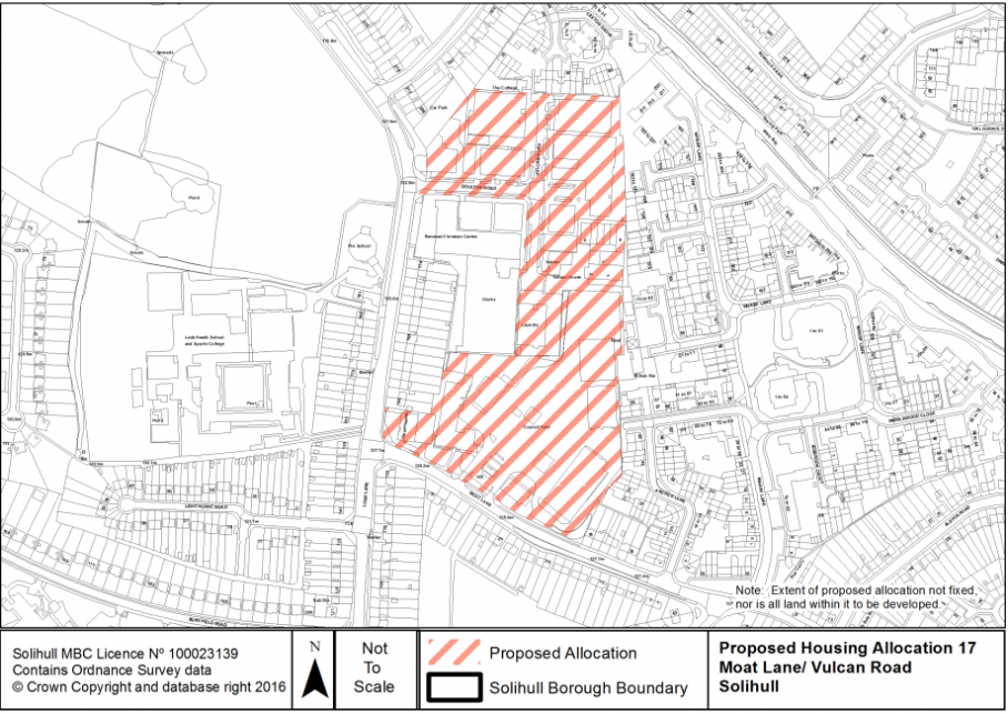
17 (222)[59] |
Moat Lane/ Vulcan Road |
Solihull |
No |
5 |
150 |
|
|
|
Viability. Current Use as Council Offices and Waste transfer facility. |
Re-use of previously developed land. Highly accessible location. |
Re-provision of Council office space. Re-provision of Waste transfer facility. Vehicular and pedestrian access improvements. Pedestrian and cycling connectivity. Provision of, or contribution to, existing play area/parks and open space. SUDs. Increased primary and secondary school provision. Potential contribution to existing local healthcare facilities. 50% affordable housing. |
|
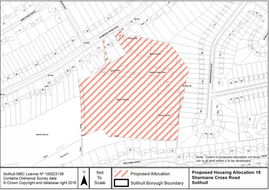
18 (245)[60] |
Sharmans Cross Road |
Solihull |
No |
3 |
100 |
|
|
|
Sports grounds. |
Sports ground is currently unused. Generally accessible location, with lower accessibility to existing GP facilities. Adjacent to Pow Grove LWS. |
Re-provision of sports pitches if not in surplus. Access into site. Pedestrian and cycling connectivity. Increased primary and secondary school provision. Provision of, or contribution to, existing play area/parks and open space. Green Infrastructure connectivity with adjacent LWS. SUDs. Potential contribution to existing local healthcare facilities. 50% affordable housing. |
440. The plans that follow[61] show the approximate extent of the intended allocation, but at this stage it should be noted that the boundaries are not fixed and further work will be undertaken on the options to be taken forward and included in the submission version of the plan.
441. Nor does the inclusion of a particular parcel of land within the allocated area mean that it is to be developed. In some instances the plans represent the area of land to be removed from the Green Belt, and to create logical defensible boundaries will mean that some existing buildings/uses that are not intended to be redeveloped will be removed from the Green Belt.
[41] SHELAA reference numbers have been included where they are wholly or partly within the area indicated for allocation. Scores are based on the draft technical assessment and are not definitive. S= Suitability; Av= Availability, Ac= Achievability scores. 1 = deliverable; 2 = developable and 3 = not currently developable within first 10 years of plan period.
[42] Rounded to the nearest 50.
[43] SHELAA 1002: S=2, Av=1, Ac=1.
SHELAA 1016: S=1, Av=1, Ac=2.
[44] SHELAA 75: S=1, Av=1, Ac=1.
[45] SHELAA 47: S=1, Av=1, Ac=1.
SHELAA 138: S=1, Av=1, Ac=1.
[46] SHELAA 126: S=1, Av=1, Ac=1.
SHELAA 130: S=1, Av=1, Ac=1.
SHELAA 176: S=3, Av=1, Ac=1. N.B. Suitability is adversely affected by impact of replacing the sports pitches.
[47] SHELAA 52: S=3, Av=1, Ac=3. N.B. Suitability and Achievability due to site comprising a roundabout. Works to remodel roundabout being undertaken separately.
[48] SHELAA 117: S=2, Av=1, Ac=1.
SHELAA 129: S=1, Av=1, Ac=2.
[49] SHELAA 229: S=1, Av=1, Ac=3. N.B. Achievability due to low value area in multiple use/ownership. Significant site clearance and relocation required.
[50] SHELAA 166: S=1, Av=1, Ac=1.
SHELAA 213: S=1, Av=1, Ac=1.
[51] SHELAA 1010: S=1, Av=1, Ac=1.
[52] SHELAA 119: S=2, Av=1, Ac=1.
SHELAA 137: S=1, Av=1, Ac=1.
[53] SHELAA 124: S=1, Av=1, Ac=2.
[54] SHELAA 1007: S=2, Av=1, Ac=1.
[55] SHELAA part 41: S=1, Av=1, Ac=2. N.B. Achievability is affected by potential adverse impact on Christmas Tree business.
SHELAA 223: S=1, Av=1, Ac=1.
[56] SHELAA 50: S=1, Av=1, Ac=3. N.B. Achievability constraints due to low value area. Site would need to come forward as part of a comprehensive redevelopment scheme.
[57] SHELAA 51: S=1, Av=1, Ac=3. N.B. Achievability constraints due to extensive site clearance required and relocation required. Site would need to come forward as part of
a comprehensive scheme.
[58] SHELAA 11: S=1, Av=1, Ac=1.
SHELAA 1009: S=1, Av=1, Ac=1.
[59] SHELAA 222: S=1, Av=1, Ac=3. N.B. Achievability constraints due to relocation of existing use, site clearance and remediation required.
[60] SHELAA 245: S=1, Av=1 Ac=1.
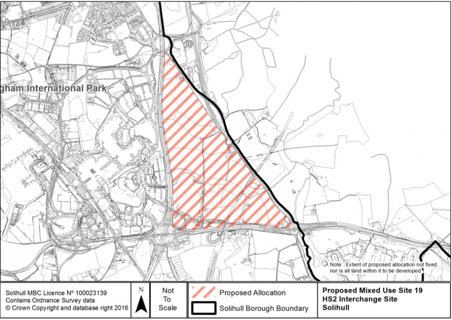
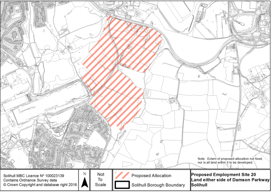
[61] Plans 1-18 match the housing allocations in the table above. Plans 19-20 relate to the table in Para. 165.