Solihull Local Plan (Draft Submission) 2020
(2) Our Borough
Overview of the Borough
- Solihull Metropolitan Borough is located on the southern edge of the West Midlands conurbation, between Birmingham and the Black Country to the west and Coventry to the east. It is bound to the north by the rural area of North Warwickshire and to the south, by rural Bromsgrove, Stratford and Warwick. The Borough is renowned for its key economic assets and strategic transport infrastructure both of regional and national significance; its attractive environment and quality of life; aspirational housing and excellent schools. All of which mean that Solihull is a desirable place in which to live, work and invest. Together, these elements combine to establish Solihull's character of 'town in country' living up to the Borough's motto: "Urbs in Rure".
- Solihull is part of the Greater Birmingham and Solihull Local Enterprise Partnership (GBSLEP), a partnership led by key businesses and local authorities to drive sustainable growth and job creation. Solihull is also a constituent member of the West Midlands Combined Authority (WMCA). The Combined Authority has a Strategic Economic Plan (SEP) which sets out how devolved powers and resources will be used to deliver a stronger West Midlands with a focus on skills, innovation, transport and inward investment. Development at Birmingham Airport and the arrival of HS2, will help make Solihull and the West Midlands region a world class business location.
- Solihull is at the heart of the national rail and motorway network with direct rail services to London, Birmingham and the north along the West Coast and Chiltern Mainlines and has excellent access to other regions in the UK through the M42, which links the Borough to the M6 at the northern boundary of the Borough and the M40 to the south. This strategic transport infrastructure, together with Birmingham Airport, has ensured the Borough is the principal national and international gateway to the GBSLEP area and the wider West Midlands area.
Historical Development
- The development of Solihull was highly influenced by the arrival of the railway stations and the 20th Century expansion of Birmingham south-eastwards. The area now known as Solihull Borough was predominantly rural with small historic towns and villages of medieval origin or earlier at Solihull, Meriden, Berkswell, Barston, Hampton-in-Arden, Knowle and Bickenhill until the end of the 19th Century, when Birmingham began to expand into rural Olton, with houses overlooking Olton Mere. Shirley originally developed from a scattered heathland settlement serving the road from Birmingham to Winchester via Oxford. Development of the Grand Union and Stratford-Upon-Avon canals and the railways also occurred during the Georgian and early Victorian periods, respectively.
- The Rural Area once formed part of a huge area of wood pasture and ancient farm lands known as Arden and evidence of previous woodland, commons and heaths are often shown in local place names. There were also a number of manor houses and halls associated with large parks situated within the Rural Area, for example, parkland associated with Berkswell Hall was once part of a medieval deer park. Much of the woodland has now been cleared and the landscape character is predominantly agricultural, characterised by a variety of fieldscapes from older, irregular piecemeal enclosure to larger planned enclosure and very large post-war fields.
- Large settlement expansion from Birmingham into Solihull occurred between 1900 and 1955, particularly during the inter-war period. This resulted in the development of semi-detached housing estates at Lyndon, Olton, Elmdon and Shirley stretching towards Solihull and, to a lesser degree, at Castle Bromwich. Detached housing development was more predominant around Solihull. Small settlement expansion also occurred in the Rural Area at Hampton-in-Arden, Marston Green, Hockley Heath, Meriden and on part of Balsall Common. During the inter-war period, large industrial areas relating to the automotive industry developed, such as the Land Rover motor works and the early example of a research and development campus at Shirley, latterly owned by TRW. Birmingham Airport was also developed at this time, opening in 1939 as a municipal airport.
- After 1945, there was a huge wave of predominantly terraced and multi-storey residential development in the north-west part of the Borough from Castle Bromwich southwards. Residential development at Kingshurst was followed in the 1960s by overspill development from Birmingham into Smiths Wood and Chelmsley Wood. At the same time, Dorridge expanded from a small settlement that was focussed around Dorridge railway station. Development at Shirley, Olton, Lyndon and Elmdon towards Solihull continued and by 1955, thus closing the gap between Solihull and Birmingham.
- Since the mid 20th Century, most residential development has occurred at Monkspath and Hillfield, Balsall Common, Cheswick Green, Meriden, Knowle and Dorridge, and most recently, since the late 1990s, at Dickens Heath. Most large scale commercial development occurred at the National Exhibition Centre in the 1970s, Birmingham Business Park since the late 1980s, Blythe Valley Park since the late 1990s, and more recently, the Touchwood Shopping Centre in Solihull Town Centre.
The Borough Now
- The regional and national impact and role of Solihull's strategic economic assets is significant. Solihull's economy produces goods and services valued at £7.5 (bn) (GVA) and supports around 109,000 jobs.[1] With an estimated 61.5% of the Borough's workforce commuting in[2], it plays a vital role in the regional economy and labour market.
- The strength and dynamism of the Solihull economy is illustrated by a range of measure, including:
- At £49,328 Solihull GDP per head was 53% higher than the UK average and 82% higher than that of the West Midlands region in 2018. Solihull has the 9th highest GDP per head out of 179 economic areas in the UK and the 2nd highest outside of London and the South East (smaller only than Edinburgh)[3]
- Over the five year period 2013-2018 GVA in Solihull increased by a total of 53% (£3.4 billion) more than double the UK average (20%)[4]
- At £77,095 GVA per filled job in Solihull was 37% higher than the UK average (£56,387) in 2018[5]. Solihull has the 8th highest GVA per job out of 179 economic areas in the UK and the 2nd highest outside of London and the South East[6]
- GVA per job in Solihull increased by £16,765 in nominal terms in the five years 2013 to 2018. At 28% this is much higher than the UK (12%) and West Midlands (15%) averages and the 6th highest out of 179 economic areas in the UK[7]
- Employment density in Solihull is 582 per 1,000 population in 2018, 22% higher than the Great Britain average (477 per 1,000). By this measure, Solihull is one of the 20 largest labour markets outside of London and the South East[8]
- Total employment in Solihull increased in seven out of nine years through to 2018 and by an annual average of 3.1% per year over this period (+3,300 jobs per year). This is three times the annual average increase recorded across Great Britain (+1.0%) and the West Midlands (+1.0%) for that period[9]
- In 2018 62% of all Solihull based employment were in Knowledge Intensive sectors a much higher proportion than the GB (54%) or West Midlands (52%) averages[10]
- Over this nine period 2010-2018 Solihull has the one of the fastest growing labour markets in Great Britain. The average annual increase in total employment in Solihull (3.1%) over this period is the 6th highest out of 206 upper tier Local Authorities in Great Britain, with the borough ranked top outside of London on this measure[11]
- The number of business enterprises per head in Solihull is lower than the UK average[12], as are the number of business start-ups[13]. However, the number of high-growth firms per head is above the UK average[14] and the growth in the number of firms with a turnover of over £5 million per annum is also high[15]
- 46% of businesses started in Solihull in 2013 were still active five years later in 2018. This five year survival rate is higher than both the UK (42%) and West Midlands (43%) averages[16]
- At £32,970 the median annual wage of full-time jobs based in Solihull in 2019 was 9% higher than the UK average and 16% above the average for the West Midlands[17].
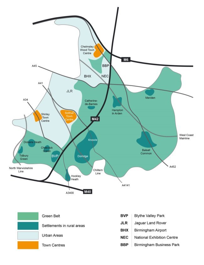
- Around two thirds of Solihull's 17,800 hectares is countryside and designated Green Belt, which separates the West Midlands conurbation from surrounding settlements. The vital strategic gap between Birmingham/Solihull and Coventry is known as the Meriden Gap. This area is predominantly rural, characterised by a series of settlements, historic villages, hamlets, scattered farmsteads and dwellings set within attractive countryside.
- These factors combine to make Solihull a highly sought after living environment and, as a result, house prices and land values across most of the Borough are substantially above the regional average.
- The Borough has a number of distinct areas and these are described in the settlement chapters.
- The illustration below is a spatial portrait of the Borough.
[1] Experian data, 2020
[2] ONS, Census 2011
[3] ONS: Regional Economic Activity by GDP (Balanced) 1998 to 2018
[4] ONS: Regional Economic Activity by GDP (Balanced) 1998 to 2018
[5] ONS: Sub-regional labour productivity by UK NUTS2 and NUTS3 sub-regions 2018
[6] ONS: Sub regional productivity 2018
[7] ONS: Sub regional productivity 2018
[8] ONS: Business Register and Employment Survey 2018
[9] ONS: Business Register and Employment Survey 2018
[10] ONS: Business Register and Employment Survey 2018
[11] ONS: Business Register and Employment Survey 2018
[12] ONS: UK Business Counts
[13] ONS: Business Demography, UK
[14] Local Resilience and the Covid-19 Economic Crisis - City Redi blogpost by Tasos Kitsos 2 April 2020
[15] ONS: UK Business Counts
[16] ONS: Business Demography, UK
[17] ONS: Annual Survey of Hours and Earnings Workplace Analysis 2019