Solihull Local Plan (Draft Submission) 2020
Ended on the 14th December 2020
(47) Spatial Strategy
Introduction
- Solihull has an enviable record of promoting and delivering growth in a way which enhances the Borough whilst at the same time not undermining the characteristics that make it special and attractive to investment. The spatial strategy will continue to manage growth and protect these characteristics.
- The 2013 Local Plan incorporated a spatial strategy that was based on a housing target that reflected the emerging requirements from the revisions to the Regional Spatial Strategy. This was a target that was 'constrained' and wasn't meeting the Borough's own needs. Furthermore, it didn't accommodate any of the shortfall that was beginning to occur across the housing market area. This plan seeks to do so by not only accommodating the Borough's own needs, but also in making a meaningful contribution towards accommodating some of the shortfall from the housing market area.
- At the time the 2013 plan was being prepared, the plans for HS2 had not reached an advanced stage. That plan acknowledged that the high speed rail link could play a key role in the future growth of the Borough, but at the time it would have been wrong to assume its development. Since then the HS2 Act has received consent, and following the issuing of the 'Notice to Proceed' in April 2020, construction has now started on the project.
- The arrival of the high speed link will have a profound effect on the Borough and this local plan review must address how its benefits can be maximised. This is in the context of the unique opportunity that is available to do so; with the interchange being located at the heart of the Boroughs key economic assets and transport infrastructure.
- The two factors outlined above represent a significant shift from the starting point of the 2013 plan and requires the spatial strategy to be looked at afresh. This is in the context that to deliver the level of growth envisaged, will require significant releases of land from the Green Belt. Solihull is not alone in having to accommodate development within the Green Belt - there are examples within the same housing market area where this has already occurred, and others are expected to follow. Nevertheless Solihull puts great value in the Green Belt and only sacrifices Green Belt if there is no other option.
- The Strategy seeks to develop the potential of each part of the Borough to contribute to the growth agenda through a place making approach aimed at enhancing Solihull as a place where people aspire to live, learn, invest, work and play; whilst recognising and protecting character and local distinctiveness. This includes realising the potential of the UK Central Area to drive growth and recognising the needs and growth potential of all communities in the Borough. Opportunities for development to meet these needs will be balanced with the importance of protecting the Mature Suburbs and the open countryside within the Solihull Green Belt.
Developing the Spatial Strategy
- The Scope, Issues and Options consultation indicated that whilst many elements of the spatial strategy in the Local Plan 2013 remained relevant, the Review is being undertaken in a different strategic context and needs to accommodate a substantial increase in the level of growth to be accommodated. A significant number of representations considered that the 2013 spatial strategy was no longer appropriate, as it needed to be amended to reflect the increased emphasis on economic and housing growth. Whilst this is accepted, it would not be right to suggest that accommodating growth at all costs is an appropriate response. Rather the balance between these potentially competing demands needs a shift towards accommodating additional growth – in a managed fashion; and provided an appropriate balance is maintained (by ensuring a sustainable pattern of development is achieved), this would be an acceptable approach.
- The Scope, Issues and Options consultation set out 7 broad options for accommodating growth as follows :
- Growth Option A – High Frequency Public Transport Corridors & Hubs
- Growth Option B – Solihull Town Centre
- Growth Option C – North Solihull/Chelmsley Wood
- Growth Option D – Shirley Town Centre & the A34 Corridor
- Growth Option E – The UK Central Hub Area & HS2
- Growth Option F – Limited Expansion of Rural Villages/Settlements
- Growth Option G – New Settlements, Large Scale Urban Extensions or Significant Expansion of Rural Villages/Settlements
Spatial Strategy
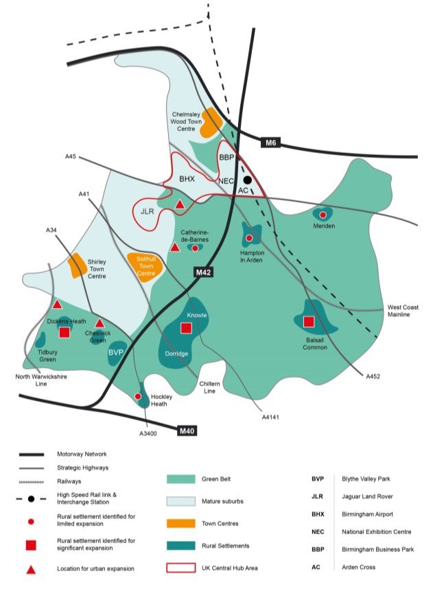
- Ideally, seeking to accommodate development needs close to where they arise is a sensible starting position and given that around 75% of the Borough's population live within the urban areas, then these areas should be the initial focus for accommodating development. This approach would support potential developments that fall within options A to D described above which are within the urban area. Appropriate development opportunities under these options are therefore preferred.
- There is extremely limited land available that could contribute towards options A to D and therefore the Council has had to look at options E, F & G (which will require land to be released from the Green Belt). In doing so it has sought strike a balance between concentrating development in a relatively small number of locations and dispersing development over a greater number of locations – a 'balanced dispersal' approach.
- The strategy also seeks to focus significant developments in locations that are, or can be made, accessible and sustainable. These locations will typically be on the edge of the urban area or within the rural settlements that have a greater range of services. This will be achieved by focussing development in the following locations:
- Located adjacent to the urban edge/a highly accessible settlement or;
- Located adjacent to a settlement that although it may be less accessible, it has a wide range of local services (including a secondary school)[18] or;
- Development that would be a proportionate addition adjacent to an existing settlement that although is less accessible still has a limited range of services available within it (including a primary school)[19].
- This approach will have the following advantages:
- Concentration could support the UK Central masterplan and HS2 growth strategy, and the investment priorities in 'Solihull Connected';
- Focussing on urban areas and sustainable urban extensions provides the best opportunity for achieving accessibility and delivering public transport improvements;
- Larger scale developments offer the opportunity for significant infrastructure improvements;
- Provision for some smaller sites will assist the early delivery of housing during the Plan period and support existing services;
- A totally dispersed pattern of growth would be unlikely to deliver the scale of growth required and be more likely to result in adverse impacts associated with piecemeal development which would affect a greater area.
- This approach would thus discourage development that is:
- Isolated from any settlement;
- A disproportionate addition to a settlement that only has a limited range of facilities;
- Occurs in relatively less accessible locations;
Site Selection
- Complementary to the spatial strategy is the approach to site selection. This is explained in more detail in the topic paper. But the principles of it are essentially that when assessing individual sites, that a higher priority is given to brownfield opportunities in the urban area/settlements and the least priority is given to isolated greenfield sites in highly performing areas of the Green Belt.
- By applying the spatial strategy and the site selection methodology, results in development opportunities coming forward across a range of the options that were identified as follows:
Growth Option E (The UK Central Hub Area & HS2):
- Land to the east of the NEC – the HS2 Interchange site
Growth Option F – Limited Expansion of Rural Villages/Settlements:
- Land to the east of Hampton-in-Arden
- Land to the west of Meriden
- Land to the south west of Hockley Heath
- Land north, south and south east of Balsall Common
- Land to the north east of Knowle
- Land east of Catherine-de-Barnes
Growth Option G – Large Scale Urban Extensions:
- Land to the north east of Damson Parkway
- Land south of Shirley (south of Dog Kennel Lane)
- Land south of Shirley (Whitlocks End Farm)
- Land east of Solihull (between Grand Union Canal and Hampton Lane)
Growth Option G –Significant Expansion of Rural Villages/Settlements:
- Land west of Dickens Heath
- Land south of Knowle
- Land east of Balsall Common
- The spatial strategy is illustrated in the following diagram:
[18] This includes Balsall Common and Knowle/Dorridge/Bentley Heath
[19] This includes Hampton-in-Arden, Hockley Heath and Meriden
For instructions on how to use the system and make comments, please see our help guide.