Local Plan Review 2026-2043 Issues and Options Consultation
Ended on the 16th March 2026
Spatial Strategy for the Emerging Plan
The emerging plan should be guided by a spatial strategy. In considering what that should be it is useful to review the strategy included in the 2020 plan, which is explored in the following paragraphs.
Spatial Strategy in the 2020 Plan
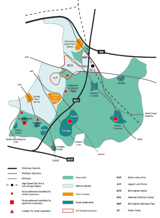
The spatial strategy in the 2020 plan was a ‘balanced dispersal’ approach that struck a balance between concentrating development in a relatively small number of locations and dispersing development over a greater number of locations.
The strategy sought to focus significant developments in locations that are, or could be made, accessible and sustainable. These locations were typically on the edge of the urban area or within the rural settlements that have a greater range of services. This was achieved by focussing development on the following locations:
Located adjacent to the urban edge/a highly accessible settlement or;
Located adjacent to a settlement that although it may be less accessible, it has a wide range of local services (including a secondary school) or;
Development that would be a proportionate addition adjacent to an existing settlement that although is less accessible still has a limited range of services available within it (including a primary school).
This approach was described as having the following advantages:
Concentration could support the UK Central masterplan and HS2 growth strategy, and the investment priorities in ‘Solihull Connected’;
Focussing on urban areas and sustainable urban extensions provides the best opportunity for achieving accessibility and delivering public transport improvements;
Larger scale developments offer the opportunity for significant infrastructure improvements;
Provision for some smaller sites will assist the early delivery of housing during the Plan period and support existing services;
A totally dispersed pattern of growth would be unlikely to deliver the scale of growth required and be more likely to result in adverse impacts associated with piecemeal development which would affect a greater area.
This approach would thus discourage development that is:
Isolated from any settlement;
A disproportionate addition to a settlement that only has a limited range of facilities;
Occurs in relatively less accessible locations.
The spatial strategy in the 2020 plan was illustrated as follows:
Spatial Strategy in the New Plan
The key question to start this consideration is what changes in circumstances since the spatial strategy was developed have occurred.
Following the update to the NPPF in December 2024, and the new Green Belt guidance in the NPPG (which explicitly excluded villages from the ability to contribute towards purposes A, B and D of including land in the Green Belt), the Council undertook an exercise to determine whether any of the rural settlements in the Borough ought to be considered to be towns rather than villages.
Thus, the overall hierarchy for the Borough is as follows:
Urban area – The contiguous built-up area on the edge of the conurbation that is formed by Solihull, Shirley, Monkspath, Olton. Lyndon, Elmdon, NEC, Marston Green, Chelmsley Wood, Kingshurst, Fordbridge, Smiths Wood and Castle Bromwich.
Some of the smaller rural settlements have more facilities than others, and those that include a primary school and a convenience store include Dickens Heath, Cheswick Green, Meriden, Hockley Heath and Hampton in Arden which some would describe as the larger villages. It is also acknowledged that in terms of population at least Dickens Heath is close to meeting at least some of the criteria that could define it as a rural town.
The Council is keen to hear views on whether and to what extent the spatial strategy should be amended for the new plan, and the following sections look at different ways this could be achieved and/or what guiding principles should be included in it.
For instructions on how to use the system and make comments, please see our help guide.