Local Plan Review 2026-2043 Issues and Options Consultation
Importance of Infrastructure Delivery
National Planning Policy on Infrastructure Delivery
- Providing supporting infrastructure is at the heart of achieving sustainable development, this is recognised in the NPPF[47]:
The purpose of the planning system is to contribute to the achievement of sustainable development, including the provision of homes, commercial development and supporting infrastructure in a sustainable manner.
The Council’s Intended Approach to Infrastructure Delivery
- The Council recognises that if it is to accommodate the level of development anticipated, it is important that it is supported by the infrastructure necessary to support the new homes, businesses and jobs that will be created in the Borough. This should be through infrastructure led development.
- Infrastructure led development means that any new homes or jobs that come forward must be supported by the delivery of infrastructure that is necessary to ensure they are ‘sustainable’. This can be delivered in advance, in parallel or after development is completed having regard to site and case specific circumstances The need for infrastructure should inform new development proposals though and be met through appropriate and proportionate developer contributions, either through in-kind delivery, S106 contributions and/or Community Infrastructure Levy – secured as part of a planning decisions. The delivery of such infrastructure is a key component of the NPPF’s golden rules[48] and is therefore essential to achieving sustainable development across the Borough and meeting the Boroughs housing and employment land requirements. Without the necessary infrastructure these requirements cannot be met, and permission may need to be refused.
- In this context it is worth setting out the types of infrastructure that may be required, and this consultation is an opportunity for residents and stakeholders to identify any other facilities that may be appropriate. In due course this will be captured in an updated Infrastructure Delivery Plan (IDP) that will be an important piece of evidence that will support later stages in the plan-making process. The IDP will also ensure that infrastructure requirements are linked to possible development sites. But, for now, we are seeking to highlight the broad areas that we currently expect to be covered, and this will enable us to identify specific facilities at later stages.
- It is useful to note here that there are some legislative tests[49] that must be met before the Council can require infrastructure to be provided (either directly or via a commuted sum that the Council would use to provide the specified facility). These tests are as follows:
- Necessary to make the development acceptable in planning terms;
- Directly related to the development; and
- Fairly and reasonably related in scale and kind to the development.
- In part, it can be summarised that through the planning system Councils can insist that ‘essential’ facilities are provided, but there is less or no scope to require ‘desirable’ or ‘nice-to-have’ facilities.
- Typically, infrastructure requirements tend to fall under the following headings, and these are explored in the following paragraphs:
- Physical – e.g. transport and flood related.
- Social – e.g. education and health.
- Green – e.g. parks, open spaces and areas for biodiversity.
- When considering what infrastructure may be required, the Council is interested in understanding what specifically stakeholders may believe is missing or inadequate. If specific examples can be provided, then this will enable the Council to take the issues into account in a more informed manner, and this is preferable to generalised comments about infrastructure being inadequate.
Physical Infrastructure
Transport
- Through the spatial strategy in the plan and its subsequent allocations, new development will need to promote sustainable patterns of development. This will include ensuring development is provided in a sustainable location, or one that could be made sustainable. In addition, the NPPF expects new developments to be planned, where possible, to limit the need to travel and offer a genuine choice of transport modes which can help reduce congestion and emissions and improve air quality and public health.
- Evidence will be prepared to test the overall levels of growth that will be taken forward as the plan progresses, and this will need to consider strategic issues, for instance, the capacity of the M42 to accommodate the additional growth.
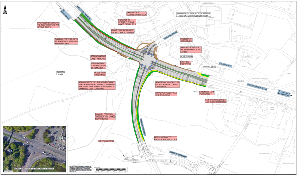
- At a more local or site level, it will be necessary to consider what sort of transport infrastructure may be needed to serve a development, and how access to it could be provided. An example of this was provided earlier in this document when reference was made to a scenario that if development were to take place to the NW of Balsall Common then through the development itself provision could be made to link Kenilworth Road with Balsall Street.
- Other physical infrastructure at the site/settlement level will be the need to ensure not just that there are pedestrian and cycle links from the development to nearby services, but also how the development could connect to the wider cycleway network. This will form part of the NPPF’s expectation of a vision led approach to planning transport infrastructure.
- Locating new development in close proximity to rail stations may be an appropriate approach to seeking to maximise sustainable locations and this is a clear aim of national policy. Notwithstanding, it will be important to consider what frequency of service is available and if (through the development) this would need to be improved. This would also hold true for the bus network.
Flood related.
- Locating new development will follow the sequential approach set out in the NPPF and will be supported by appropriate Flood Risk Assessment (FRA) evidence. However, even at this early stage it is important to remember that new development has the potential to provide ‘betterment’ – i.e. in making provisions for new development a scheme will need to take into account any existing issues that could then be incorporated into a mitigation scheme that deals with both.
- The drainage strategy for new developments often requires the provision of a Sustainable Urban Drainage Scheme (often known as SUDS) which incorporates a number of techniques to prevent flooding both on the site being developed and areas downstream. One way this is achieved is through restricting run-off rates from a development to ‘greenfield’ run off rates and holding water back in balancing pools. This is instead of storm water running straight from driveways and roads in the new development straight into the main drainage system serving the wider area. This is one area where through responding to matters of Climate Change we may need to consider what volume of run-off rates should be planned for and whether there is justification for exceeding national expectations. The Council will consider this matter in detail alongside partners such as the Lead Local Flood Authority and the Environment Agency.
- Some recent experiences of flooding have resulted from short duration, high intensity storms, leading to localised pluvial[50] flooding. Through updated Flood Risk Assessment work this will explore what rainfall events should be taken into account and views on this matter at this stage will help shape the work to be undertaken. This will include existing and proposed topography; sufficient SUDS requirements; property level protection and permeable surfacing along with the utilisation of water harvesting if possible/practicable.
Digital Infrastructure
- Digital infrastructure in the form of full fibre broadband connections and next generation of mobile technology (such as 5G) is essential for economic growth and social well-being. As such the Council is keen to understand where current gaps in provision may exist so that work can be undertaken with providers and/or site developers to improve network coverage.
Social Infrastructure
- When considering what social infrastructure ought to be provided as a result of new developments it should be noted that it will have a capital cost to it, and an on-going revenue component. The capital costs will relate to the physical side of the provision – i.e. the building to accommodate a service. The revenue costs will usually relate to the operational costs (including staff costs) of providing a service.
- It is a reasonable expectation that the capital costs in providing social infrastructure should be funded via the development, but the on-going revenue costs are usually beyond the scope of being the development’s responsibility. These would be expected to be funded via public funding, for instance directly from the Government or Local Authority funds. In this way a school building could be provided for by a development, but the on-going costs of paying for the teaching staff would be publicly funded. In the same way a medical centre could be funded through a new development, but the costs of the doctors/nurses etc would be publicly funded.
Education
- As part of the 2020 plan, it was identified that the scale and distribution of new housing development would generate the need for 4 new primary schools. These would be located in Balsall Common, Blythe area, Knowle/Dorridge and Arden Cross. Subsequent planning applications have included these within the proposals[51]
- A similar process will be followed for the new plan once it is established how much housing growth will be accommodated, and where it will be located. It is normally assumed that for every 100 houses they will be occupied by 18 children of secondary school age and 34 children of primary school age. This helps to determine (on a development-by-development basis) the number of school places that would arise from a development. Pupil yield increases with the levels of affordable homes a development provides so this may vary depending on an increase in the level of affordable housing to be provided. If capacity doesn’t exist at a school, then the developments will be expected to fund the additional places created, either a new school or by extending an existing one. A rule of thumb is that if 2,000 new houses are to be provided, this would require a new two form entry primary school. Generally speaking, the delivery of new schools is expected to be located in a way that means they are directly accessible by the catchment they intend to serve and encourage active travel or public transport to help remove the reliance on car usage. This also creates wider health benefits in terms of mobility and air quality for example.
- The scale and distribution of growth under the 2020 plan was not expected to immediately give rise to a new secondary school[52], and existing establishments were expected to be able to be expanded as necessary. This may not be the case with the emerging local plan, and it is thought that the Blythe area of the Borough and development at Arden Cross may need to be a particular focus for seeking to identify where a new secondary school could be accommodated. A similar rule of thumb for a secondary school is that 4,000 – 6,000 new houses across a secondary school planning area, are required to support a new school. In considering the need for a new secondary school we must also have regard to opportunities to promote active travel to and from school sites – ensuring new schools provide a focal point for local communities and where possible supporting more than just educational infrastructure.
- In addition, to ensure infrastructure is in place across the wider education need, the Council will also need to seek contributions for SEND provision, post-16 and early years’ needs and where necessary to support the school transport requirement.
Health
- The Council has been working with the Birmingham & Solihull Integrated Care Board[53] (BSOL ICB) in order to seek health infrastructure to support the development in the 2020 plan. This has resulted in developing a model that predicts the level of demand[54] for these services that would occur from a development:
- Primary care (GPs).
- Community care.
- Mental health.
- Acute outpatients.
- Acute emergency.
- This level of demand is then translated into the physical space needed at health establishments and this drives the financial contribution that is sought from developments, so that the physical health estate can accommodate the additional demand. As for schools/teachers, it is then for staffing costs for doctors/nurses etc to be publicly funded.
- The Council will continue to work directly with the BSOL ICB[55], as the co-ordinator/commissioner of health services, rather than individual health care providers such as hospital trusts and individual GP practices. This relationship would not prevent these service providers from commenting on how services should be provided, but it will be expected that this will be undertaken through the ICB.
- Some developments in the Borough may result in health services for the Borough’s future residents being provided beyond the area covered by BSOL ICB, for instance in Coventry/Warwickshire. To provide consistency and an efficient Development management process, it has been agreed with BSOL ICB that it will act as a single point of contact to coordinate heath service responses to planning applications. It then it will seek to collaborate[56] with any relevant adjacent ICBs to ensure funds are used where they are required as a result of the development taking place.
Police
- It is unlikely that the scale of growth that may be incorporated into the local plan will be of a sufficient size or distribution that would generate the need for an additional police station, or extending existing premises. Notwithstanding, the way the police operate with seeking to provide a presence in communities could be affected by new development. This may generate the need for supporting facilities (e.g. car charging points) to be provided in new developments and/or more equipment to support out of station working.
- As with other social infrastructure, there may be a role for contributions from developments to be used to improve the police estate, but it is unlikely to be justified that such contributions are used to support revenue operations (e.g. staffing).
Other Social Infrastructure
- Are there any other types of social infrastructure that should be considered, for instance community or recreational facilities? If so, the Council would need to ensure there is evidence of need to support an argument that it is necessary and that there is a clear plan in place for delivery – i.e. which organisation would be responsible for the facility and would there be a sufficient population to support the viability of the facility in the future.
- Some types of infrastructure that could fall into this category could be provided as a commercial opportunity if market conditions were right, for example convenience retail facilities that would serve a new residential area.
Green Infrastructure
- One of the seven ambitions in the 2025 Council Plan is that Solihull is an attractive and aspirational place. It noted:
“Given that two thirds of the borough’s land is green belt, we need to ensure that future developments maintain respect for the environment. This includes maintaining space for nature and providing a biodiversity net gain and ultimately protecting and complementing the beauty of our borough.”
- Green infrastructure is defined in the NPPF as:
“A network of multi-functional green and blue spaces and other natural features, urban and rural, which is capable of delivering a wide range of environmental, economic, health and wellbeing benefits for nature, climate, local and wider communities and prosperity.”
- Green infrastructure can therefore provide for a mix of uses and activities; some of which will prioritise public accessibility and others may need to be set aside for wildlife to enjoy without disturbance.
Adaptation to the effects of Climate Change
- Well-designed green infrastructure can contribute to ‘nature-based solutions’, an alternative to hard engineering when tackling the impacts of climate change. Planted areas can slow water flows, decrease surface run-off, even out temperature fluctuations, trap pollution and encourage biodiversity.
Parks and Open Spaces
- New and enhanced open spaces are important as they provide opportunities for recreation, physical activity and enjoying nature on your doorstep.
Design
- Care and attention must be taken at the design stage to ensure the new buildings are integrated into their surroundings not just ‘dropped in’, and how open space and soft landscaping is treated in and around the development is key to this process.
Areas for biodiversity
Linear green infrastructure such as hedgerows and waterways can be important wildlife corridors. Walking and cycling paths can also be created alongside these corridors with wildlife stepping stones in between such as ponds, copses and wildflower meadows.
- Biodiversity Net Gain is discussed in more detail below.
Natural Capital Investment Strategy
- The Natural Capital Investment Strategy (NCIS) sits alongside our existing initiatives and strategies and is our delivery mechanism for responding to the biodiversity crisis, by protecting, restoring and enhancing nature in a sustainable way for all.
- The NCIS sets out a series of actions from assessing the natural capital value of all relevant Council assets – especially parks and open spaces – to producing a natural capital database including an infrastructure assets map.
Playing Pitches
- Planning policy has a role to play in ensuring that there are sufficient facilities for more formal recreational, such as playing pitches. The Council has adopted[57] a Playing Pitch & Outdoor Sports Strategy[58] which includes aims to ‘protect’, ‘enhance’ and ‘provide’ facilities, and it supports the approach to requiring developments to contribute towards new facilities[59]. This work was undertaken in collaboration with Sport England and the National Governing Bodies of the sports involved.
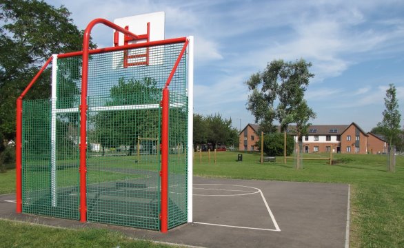
- Rather than these new facilities being provided in a piecemeal fashion where each development site that may be large enough to accommodate a single playing pitch does so, a more comprehensive approach to delivery has been pursued through seeking to identify potential locations for new ‘sporting hubs’. Providing facilities in a hub fashion allows a more critical mass to be provided and allows sharing of facilities (car parking and changing rooms) that enables the facilities to be more sustainable in the long term.
- Through work based on the 2020 plan it was identified that hubs would be required in Balsall Common, Blythe, Knowle/Dorridge and east of Solihull[60]. Site identification and feasibility work has since been undertaken. Under the new plan it’s likely that hubs will continue to be required in these locations, but they may need to be designed to be larger (i.e. accommodate more pitches) as a result of the additional growth expected to be required in the new plan or across additional locations.
- The Council is also in the process of refreshing the Indoor Sports Facility Strategy.
Other Infrastructure
Phasing Infrastructure
- In some cases, the infrastructure required in connection with development will need to be in place before the new houses are occupied. This will particularly be the case for the physical infrastructure needed to support the development but will be informed by site/case specific considerations. However, some infrastructure provision will be phased so that although it may not be in place as the first houses are occupied, arrangements will be in place for it to be provided at an appropriate time.
- This is best illustrated by way of an example. As noted above, a new development of 2,000 dwellings would require a new primary school. A development of this size would take at least 10 years, and possibly longer, to be ‘built out’ and it would be impractical to require the new school to be open as soon as the first dwelling is occupied. What it will require is a phased approach so that once the right critical mass of dwellings have been completed (and thus enough children at the school to make operating it viable) the school will be ready.
- This approach may require some transitional arrangements to be put in place that will be determined on a case-by-case basis. This could include initially operating a school on the basis of a one form entry, before moving to two form entry.
Infrastructure Funding
- It is anticipated that most infrastructure needed as a result of new development will be funded privately via the development itself, and ultimately this is usually reflected in the land prices that developers pay for the land itself. It should be noted that funding from this source is finite and there may be cases where to ensure development remains viable it will not be possible to fund all infrastructure asks. Plan-wide viability evidence will be updated in this respect.
- The Council adopted a Community Infrastructure Levy (CIL) charging schedule in 2016. Alongside the plan-wide variability evidence noted above, the Council will review its charging schedule. The Council will also explore a S106 or tariff approach in areas of significant growth.
- It may be necessary to explore public funding opportunities, especially if infrastructure of a more strategic scale is required. It may be the case that organisations such as the Department for Transport or West Midlands Combined Authority[61] may be approached to assist with funding solutions.
- As highlighted above, the council is keen to explore opportunities where infrastructure can be provided ‘in kind’ to help link the necessary infrastructure directly to the delivery of new homes. Stage 2 of the Balsall Common Relief Road is a prime example as part of the current Barratts Farm proposals. The Council considers this offers an efficient and viable option to ensure delivery and maximise benefits for new residents and the existing communities. Similarly, it will be important to understand where capacity may already exist in local infrastructure provisions (such as primary schools for example) where the delivery of new homes could help ensure their long-term viability and benefit to the community.
Cross Boundary Infrastructure
- In some instances, developments may take place close to the Borough boundary but will rely on infrastructure facilities in an adjacent Council area. This could be developments being constructed in Solihull, but reliant on facilities in an adjacent area; or developments in an adjacent area that are reliant on facilities in Solihull.
- As an example of the latter case, if development were to take place in another authority’s area (but remote from that area’s settlement hierarchy), but in close proximity to a settlement or facilities in Solihull; this would naturally cause residents of the new development to seek to use the facilities in Solihull as they would be closest, for instances to access a school. Furthermore, most of the traffic movements would be likely to take place in and around the settlement in Solihull. Whilst utilising local infrastructure may also support a more effective and sustainable approach helping reduce environmental impacts caused by increased travel, this would place additional infrastructure demands on the Council’s services.
- To address these potential eventualities, the Council will work with adjacent local authorities, including through the production of Statements of Common Ground[62], to agree that in the event that permissions are granted, the authority that is expected to accommodate the infrastructure strain will receive the associated mitigation through S106 agreements and Community Infrastructure Levy payments (as appropriate on a case by case basis).
[47] Paragraph 7.
[48] Paragraph 156.
[49] AS set out in Regulation 122(2) of the Community Infrastructure Regulations (2010) as amended.
[50] Pluvial flooding occurs when the amount of rainfall exceeds the capacity of urban storm water drainage systems or the ground to absorb it. This excess water flows overland, ponding in natural or man-made hollows and low-lying areas or behind obstructions. This differs from fluvial flooding, when levels in a river, or stream rise, allowing water to flow onto surrounding land.
[51] References for Balsall Common, Dog Kennel Lane, but Knowle???
[52] Although it was noted that in the Aarden Cross/NEC area a new secondary school may have been required towards the end of the plan period, or beyond, depending on the housing mix of development to be accommodated in the area.
[53] Integrated care boards (ICBs) are NHS organisations responsible for planning health services for their local population. They manage the NHS budget and work with local providers of NHS services, such as hospitals and GP practices.
[54] For instance the number of GP contacts would arise from a typical development using contact rates for under 16, 16 – 65 and over 65’s.
[55] The 11 Integrated Care Boards in the Midlands are in the process of being grouped as clusters with one being the NHS Birmingham, Black Country and Solihull. (see NHS England — Midlands » How the NHS structure in the Midlands is changing). In due course, these clusters are likely to lead to formal mergers, but this is not expected until April 2027.
[56] With the Council’s agreement.
[59] Based on Sport England’s Playing Pitch Calculator that essentially converts the number of dwellings proposed at a site into the number of playing pitches that would be required to satisfy the additional demand.
[60] This is not to say that sporting and recreational facilities elsewhere in the Borough aren’t important, rather it is an approach to seek to provide additional facilities where new development is expected to take place.
[61] Particularly if the strategic infrastructure is required in order to deliver its Spatial Development Strategy.
[62] A Statement of Common Ground (SCG) should be produced, published and kept up to date by the signatory authorities as an accessible and public record of where agreements have or have not been reached on cross boundary strategic issues. The purpose of the SCG is to document the cross-boundary matters being addressed and progress in cooperating to address them. It is the means by which authorities can demonstrate that their plans are based on effective and ongoing cooperation and that they have sought to produce strategies that as far as possible are based on agreements with other authorities.