Draft Submission Plan (Regulation 19)
Protecting Green Belt Land Comment
Introduction
302.Around two-thirds of the Brough is made up of land designated as Green Belt. There are few other places in the country where conurbations or cities the size of Birmingham/Solihull and Coventry are separated by Green Belt in quite the same way as occurs in the West Midlands. This strategically important area is known as the Meriden Gap. Comment
303.National policy makes clear that established Green Belt boundaries should be altered only in exceptional circumstances and only when a local plan is being prepared or reviewed. It also describes the circumstances when built and other development should be considered as an exception to inappropriate development. Comment
304.The pressure on the Green Belt in Solihull has been intensified by the requirement for development emerging from housing needs; the lack of vacant and derelict land in the Borough; and local requirements for employment land, waste management and mineral extraction. This is reflected both in the significant number of sites in the Green Belt in the SHELAA, and the paucity of sites in the urban area. Comment
305.Significant adjustments to Green Belt boundaries are required in the UK Central Hub Area to provide an appropriate planning framework for the Council’s ambitions for the HS2 Interchange and adjoining area, and to meet the needs of the key economic assets within the area. Further significant adjustments are required elsewhere to meet local housing and employment land needs. Where land is to be deleted from the Green Belt as part of this Plan, exceptional circumstances are considered to be met to justify the change in boundaries, as required by the NPPF. Comment
National Planning Policy Changes
306.The 2024 NPPF saw what some have described as the most fundamental reform to Green Belt policy since it became a national planning policy in the 1950s. This included the introduction of the concept of Grey Belt[34], and since then reforms in the 2026 NPPF have seen further significant amendment (for example in relation to development near to railway stations) which collectively means that Green Belt designation is less of a barrier to development than it once was. Comment
307.These changes in national policy will either need to be directly addressed in this plan or will have an indirect impact as a result of how the determination of planning applications will be influenced by the new NPPF. Comment
Green Belt Assessment (GBA)
308Given the significant changes to national Green Belt policy, it was considered that the Council’s 2016 GBA would not provide a suitable evidential basis for considering Green Belt matters and therefore a fresh GBA was undertaken, taking into account the 2024 NPPF and 2025 PPG. This culminated with the publication of the new GBA in July 2026. Comment
309The GBA considers all of the Green Belt in the Borough (at either a parcel or broad area level) and assesses the area in question against the five purposes of including land in the Green Belt, namely: Comment
- to check the unrestricted sprawl of large built-up areas;
- to prevent neighbouring towns merging into one another;
- to assist in safeguarding the countryside from encroachment;
- to preserve the setting and special character of historic towns; and
- to assist in urban regeneration, by encouraging the recycling of derelict and other urban land.
310.National policy sets out that it is only purposes A, B and D that are to be taken into account when assessing whether land should be considered as Grey Belt or not. Comment
311.The NPPF (paragraph 146) states that when considering whether exceptional circumstances exist, meeting needs can be such a circumstance and Green Belt boundaries should be reviewed: Comment
“to meet these needs in full, unless the review provides clear evidence that doing so would fundamentally undermine the purposes (taken together) of the remaining Green Belt, when considered across the area of the plan.”
312.To assist in assessing whether this test is met, the GBA sought to identify areas of fundamental importance. It noted[35]: Comment
“Areas of ‘fundamental importance’ are those which perform a strategically important role against the Green Belt purposes within the context of the wider Green Belt across the plan area and are therefore considered the most sensitive to change.”
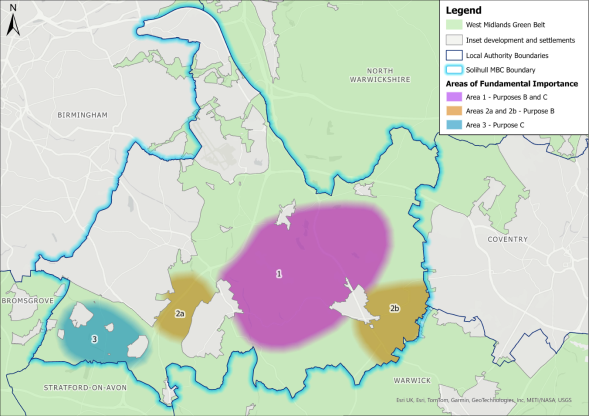
313.The GBA went on to identify three such areas as follows: Comment
- Area of Green Belt within the Meriden Gap (Area 1)
- Areas of Green Belt located between towns (Areas 2a and 2b)
- Areas of Green Belt to the south and southwest of Solihull/Shirley (Area 3).
314.These are indicated in figure 11 of the GBA which is reproduced below: Comment
Policy SMBC/GB1: Green Belt Boundaries Comment
- Land designated as Green Belt in the Borough is identified on the Policies Map. Development proposals within the Green Belt will be subject to consideration against the NDMPs of the NPPF.
Policy SMBC/GB2: Limited Infilling in Villages Lying in the Green Belt Comment
- For the purposes of NDMP GB7 (1)(c), the following settlements are considered to be villages where limited infilling may be considered as not inappropriate:
- Chadwick End
- Barston
- Berkswell
- Bickenhill
- Eastcote
- Illshaw Heath
- Temple Balsall
- For the purposes of NDMP GB7 (1)(c), limited infilling shall be interpreted as the filling of a small gap within an otherwise built-up frontage with not more than two dwellings.
Amending Green Belt Boundaries Around Settlements as a Result of Recent Permissions for Development
315.The now withdrawn 2020 Draft Submission Plan included significant proposals for Green Belt land release of some 574ha[36]. Following submission of the plan for examination, a number of planning applications were submitted for many of the sites to be allocated. These ranged in size from proposals for around 80 dwellings, to some that were just short of 1,000 dwellings. Initially, these submissions were made on the basis of dealing with the technical development management issues that inevitably arise as a result of large-scale developments, so that when the plan was adopted (and the land removed from the Green Belt) they could be determined accordingly. As the examination of the plan became protracted, some applicants amended the basis of their applications to make a case for demonstrating ‘very special circumstances’ (VSC) for the proposed development that they then invited the Council to determine. Comment
316.Following the publication of the 2024 NPPF the basis of some of these submissions was amended further to argue that under the new approach to Green Belt policy, the sites ought to be considered as Grey Belt, and with other criteria in paragraph 155 of the NPPF being complied with, the proposals should be viewed as not being inappropriate. Comment
317.The Council has sought to determine such applications is a positive manner, where justified. This has therefore resulted in a number of planning permissions being in place (with others having a resolution to grant that are likely to be converted into permissions before this plan is adopted). There is no reason to believe that these permissions will not, in due course, be implemented, and as this occurs this will create anomalies in the boundaries of the Green Belt around the rural settlements or around the urban edge. Comment
318.Similar considerations are also applicable to more speculative applications that have been submitted in relation to Green Belt sites that weren’t necessarily included in the 2020 plan as an allocation but nevertheless have now got permission. They too will create anomalies in the boundaries of the Green Belt around the rural settlements or around the urban edge. Comment
319.To address these potential anomalies, it is proposed that the Green Belt boundaries be amended to exclude the sites where permission has been granted. These are considered in more detail on a site-by-site basis in the settlement chapters. However, the over-arching exceptional circumstance for this approach is common to all and is set out as follows: Comment
- The strategic purposes of the Green Belt would continue to be met by the surrounding Green Belt land.
- With the implementation of these permissions, the settlements will evolve into a more substantial and permanent built-up areas, such that the additional developed area no longer meaningfully contributes to Green Belt openness.
- Were the existing washed-over designations to remain they would create an illogical Green Belt boundary, with Green Belt policy applying to predominantly urbanised land rather than to open countryside.
- A clearly defined inset boundary can provide a stronger and more enduring Green Belt edge than what would be a washed-over approach.
- Defining a settlement boundary provides greater certainty and clarity for decision-making, enabling appropriate infill, redevelopment and housing delivery within a planned framework.
320.The permissions simply reinforce that those sites are now committed and that the Green Belt boundary should be realigned to reflect the adopted planning strategy. Comment
321.For the allocations in the 2020 plan that have not received planning permission, they are included (if still appropriate) as an allocation for a proposed development as set out in the settlement chapters. Comment
Washed Over Settlements
322.Alongside the GBA a Green Belt Village Study (GBVS) was also published in July 2026. The principal purpose of this study is to objectively assess the extent to which villages washed over by the Green Belt meet the NPPF requirements of paragraph 150: Comment
“If it is necessary to restrict development in a village primarily because of the important contribution which the open character of the village makes to the openness of the Green Belt, the village should be included in the Green Belt. If, however, the character of the village needs to be protected for other reasons, other means should be used, such as conservation area or normal development management policies, and the village should be excluded from the Green Belt.”
323.Such an assessment was considered important since it was not considered in detail when the 2013 SLP was drawn up and the current position remains from a period when the (then) relevant national policy considerations were in the 1995 PPG2 – Green Belts. Comment
324.The study looked in detail at the following ‘washed over’ settlements Comment
- Barston
- Berkswell
- Bickenhill
- Chadwick End
- Cheswick Green
- Eastcote
- Illshaw Heath
- Millisons Wood
- Temple Balsall
- Tidbury Green
325.It should be noted that of the above, Cheswick Green and Tidbury Green are already partly inset from the Green Belt. This is largely as a result of the treatment of so-called long-term housing sites in the 1997 and 2006 Unitary Development Plans where two sites at Tidbury Green and one at Chadwick End were treated as potential future housing sites and so weren’t designated as Green Belt, whereas the rest of each settlement was washed over with the Green Belt designation. All three of these sites have now been built out and this creates somewhat of an anomaly with the settlements where parts of the area are (washed over) Green belt and parts are not designated Green Belt. Comment
326.The study recommends that the whole of these two settlements should be inset from the Green Belt and additionally the small settlement at Millison’s Wood should be inset. Comment
Policy SMBC/GB3: Insetting Settlements from the Green Belt Comment
- The Green Belt boundaries around the following settlements are revised so that all of their built-form will be inset from the Green Belt:
- Cheswick Green
- Millison’s Wood
- Tidbury Green
327.This approached is justified as: Comment
- The strategic purposes of the Green Belt would continue to be met by the surrounding Green Belt land.
- The settlements have evolved into a substantial and permanent built-up areas, such that its developed character no longer meaningfully contributes to Green Belt openness.
- The existing washed-over designation creates an illogical Green Belt boundary, with Green Belt policy applying to predominantly urbanised land rather than to open countryside.
- A clearly defined inset boundary can provide a stronger and more enduring Green Belt edge than the current washed-over approach.
- Defining a settlement boundary provides greater certainty and clarity for decision-making, enabling appropriate infill, redevelopment and housing delivery within a planned framework.
- In the case of Cheswick Green and Tidbury Green this removes the current anomaly whereby parts of each settlement are treated differently and thus the new boundary will be logical.
328.The above justification contributes to the exceptional circumstances needed to justify making changes to the Green Belt boundary. Comment
[34] See the glossary in this document for an explanation of how Grey Belt is defined.
[35] Section 6.1
[36] Paragraph 421 of the plan indicated this would be 140ha for the HS2 Interchange, 94ha for the employment allocation at Damson Parkway and 340ha for the residential allocations.
