Draft Submission Plan (Regulation 19)
Meriden Comment
The Settlement Now
689.Meriden is located approximately 9km to the east of Solihull Town Centre and the wider parish forms the north-eastern corner of Solihull Metropolitan Borough Council, bordering Coventry to the east and North Warwickshire to the north. It lies in the rural ‘gap’ between the Coventry and Birmingham conurbations (known as the ‘Meriden Gap’). Comment
690.The main settlements within the Parish are Meriden Village itself (where approximately two thirds of the population of the Parish live), Millison’s Wood (approximately 1.5km to the east of Meriden Village) and Eaves Green. At the 2022 Census, the parish had a population of approximately 3,246 residents living in 1,324 households, representing growth from the 2011 Census when the population was around 2,800 and there were approximately 1,220 households. Further residential development has subsequently been permitted within the parish, including 75 affordable dwellings at land east of Maxstoke Lane, which commenced construction in 2025. Comment
691.The A45 (Birmingham to Coventry Road) crosses through the Parish just to the north of Meriden Village. It is located approximately 2.5km to the east of junction 6 of the M42 and the entrance to the National Exhibition Centre (NEC), Birmingham International Airport and Birmingham International Rail Station. Meriden benefits from regular bus services, with the National Express West Midlands X1 route providing frequent connections between Birmingham and Coventry via Birmingham Airport and the NEC. In addition, a Stagecoach service provides links to Solihull and Coventry, while the Flexibus service connects Meriden with neighbouring rural settlements. These services provide access to key employment, retail, education and transport hubs, although service frequencies are generally lower during evenings and weekends than during daytime periods. Comment
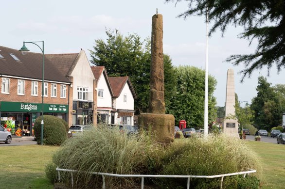
692.The settlement derives its special character from its rural setting and its historical roots. There are two conservation areas: Meriden Green Conservation Area (including the village green at the centre of the settlement and the ‘old’ village located on Meriden Hill with its cluster of listed buildings including the church of St Laurence. Comment
693.The area surrounding the village of Meriden is predominantly Green Belt. It is a mix of agricultural land and woodland (parts of the former Forest of Arden) with some large sand and gravel extraction quarries to the west. Comment
694.The village has a small local centre around the Village Green, providing a range of shops and services including a recently developed sports and play facility on the south-west side of the Green and the Meriden Practice GP surgery. The village is also served by Meriden Church of England Primary School which accommodates up to 200 pupils. The nearest secondary school is Heart of England Secondary School located in Balsall Common. Comment
695.The Meriden Neighbourhood Development Plan was approved by local referendum in May 2021 and was formally "made" by Solihull Metropolitan Borough Council in June 2021. The Plan now forms part of the statutory development plan for the area and is used alongside the Solihull Local Plan in the determination of planning applications within the parish. Comment
The Settlement in the Future
696.Meriden is identified as a village within Solihull's rural settlement hierarchy and serves an important role as a sustainable rural community with a range of local services, community facilities and public transport connections. The village benefits from its proximity to the A45, M42, Birmingham Airport, Birmingham International railway station and the NEC, providing good accessibility to employment, services and public transport. Comment
697.The village supports a range of local facilities including a primary school, GP surgery, village centre and recreation facilities. Any additional community, retail or service provision should be directed towards the village centre and other accessible locations to reinforce the sustainability of the settlement and support the day-to-day needs of residents. Comment
698.The distinctive historic and rural character of Meriden remains one of its defining features and should be conserved and enhanced. Particular regard should be given to the significance of the Meriden Green and Meriden Hill Conservation Areas, together with the wider landscape setting of the village and its heritage assets Comment
699.The principal constraints to development remain the surrounding Green Belt, the Borough boundary, immediately north of the village and environmental, heritage and landscape considerations affecting the parish. This includes the mineral safeguarding area (sand and gravel) located to the west. The Council's 2026 Green Belt Assessment has replaced the previous 2016 Strategic Green Belt Assessment and reflects the requirements of the revised National Planning Policy Framework, including consideration of ‘grey belt’ land. Comment
700.The Meriden Neighbourhood Development Plan (made June 2021) also includes a Local Housing Needs Assessment which should help inform any housing proposals for the settlement. Comment
701.The High Speed 2 (HS2) route will pass approximately 3km to the west of Meriden serving the new Interchange Station located adjacent to the NEC, Birmingham International Airport and Birmingham International Station. The Interchange Station will be approximately 4km to the north-west of Meriden and remains under construction. Construction activity associated with HS2 is expected to continue in the area for a number of years and may affect traffic movements. In the longer term, the operation of the Interchange Station is likely to increase accessibility and could place additional pressure on local services and housing demand in nearby settlements, including Meriden. Comment
What is Required for the Settlement in the Future
702.Development Principles - Any development within or adjoining Meriden should contribute positively towards meeting the Borough's housing needs whilst supporting the long-term sustainability of the parish. Development should respond to local needs identified through the Meriden Neighbourhood Plan, particularly in relation to housing mix, affordability, infrastructure capacity, environmental quality, biodiversity enhancement and respect and maintain the distinctive rural character of the settlement through appropriate design, scale and layout. Comment
703.Local Infrastructure Requirements – Meriden benefits from a range of local facilities; however, future development must be supported by proportionate assessment of infrastructure capacity. Proposals should demonstrate that sufficient capacity exists, or can be provided, in local schools, healthcare facilities, transport networks, utilities and community facilities. Contributions towards infrastructure improvements will be required where development generates additional demand. Comment
704.Pedestrian and Cycling Connectivity – New development will be expected to deliver safe, attractive and accessible walking, wheeling and cycling connections both within development sites and to destinations beyond site boundaries. Priority should be given to improving access to local facilities, schools, public transport services, recreational routes and surrounding settlements. Development should contribute towards the delivery of the Council's active travel objectives and provide connections to existing and future walking and cycling networks. Comment
705.Local Aspirations – The Meriden Parish Neighbourhood Development Plan (made in June 2021) forms part of the statutory Development Plan for the Borough. Development proposals should demonstrate how they respond to the objectives and policies of the Neighbourhood Plan. These include protecting the character of the parish, supporting local infrastructure, maintaining the Green Belt, improving sustainable transport options, addressing environmental issues and providing housing that meets identified local needs, including affordable housing and accommodation suitable for older people. Comment
706.Local Housing Need – The Meriden Neighbourhood Plan and its supporting Local Housing Needs Assessment provide important evidence regarding local housing requirements. Housing proposals should demonstrate how they respond to the latest evidence of local need and contribute to creating balanced and sustainable communities Comment
707.Health provision – The Council is working with the BSOL ICB to establish the impact of new development on local GPs and other services, and how this can be addressed. Comment
708.Community Infrastructure Levy (CIL) – As Meriden has an adopted Neighbourhood Plan, the Parish Council is entitled to receive 25% of relevant Community Infrastructure Levy receipts arising from development within the parish. These funds provide an important opportunity to support local infrastructure improvements, community facilities, environmental enhancements and other projects identified as local priorities Comment
709.The settlement is suitable for consideration for limited growth. This reflects the sensitive environmental nature of the area, the character of the villages and the need to manage the capacity and viability of local infrastructure. Comment
710.A mix of market and affordable housing and specialist housing to meet the needs of older people should be provided in the settlement. There will need to be a careful balance struck between making the most efficient use of land and respecting the character of the local area Comment
Proposed Allocations
711.Planning permission was granted in May 2024 for 75 affordable dwellings at land off Maxstoke Lane/Birmingham Road on the western edge of Meriden and construction commenced in 2025. The development provides a significant contribution towards identified local housing needs, particularly affordable housing and represents a major expansion of Meriden’s housing stock. A small parcel of land fronting the Birmingham Road remains without planning consent having originally formed part of the ME1 allocation. This remains referenced within the table at Para 142 and Row 12 of the housing land supply table (para 109) and has a capacity of c10 dwellings. Provisions within the 2024 consent would ensure access into this site from the newly adopted highway as part of the existing consented development. This land will be removed from the Green Belt alongside the wider Maxstoke Lane/Birmingham Road development. Comment
712.No further allocations in Meriden are proposed in this Plan. Comment
